What's new
Tracking all MapChart-related updates.
Version 7.2.1-2 27 Jan 2026
- Fixed an issue with the download process on some devices.
Version 7.2.0 - 26 Jan 2026
- Added default configurations for Africa Detailed, Americas Detailed, Asia Detailed, and Europe Detailed. You can now color the whole map by country with a single click.
- Map updates:
- World Subdivisions/Africa Detailed: updated districts of Uganda.
- World Subdivisions/Europe Detailed: merged Varakļāni into Madona municipality (Latvia).
- World Subdivisions/Asia Detailed: added Ağdərə district and renamed Xanlar to Göygöl (Azerbaijan).
- Belgium: updated the municipality of Beveren-Kruibeke-Zwijndrecht.
- Indonesia: multiple naming and island coverage fixes.
- Added visual feedback when selecting a color/pattern from the legend box (right-click).
- Fixed an issue where releasing the mouse after resizing the legend width could color the map underneath.
- Fixed redo for the isolate feature (isolate → undo → redo).
- US Counties: fixed county names not showing when loading a configuration with an isolated state.
- Improved the eyedropper tooltip when using the keyboard shortcut.
Version 7.1.4 - 15 Jan 2026
- Fixed an issue with the download process on some devices.
- Fixed a long-standing bug where clicking to change the color of a group in the legend would not work.
Version 7.1.3 - 13 Jan 2026
- Europa Universalis V locations map: added the ability to color all wastelands (impassables) with a single click, to speed-up map-making. Use the Color Wastelands button in the More Options section.
Version 7.1.2 - 12 Jan 2026
- Hearts of Iron IV maps: updated the 1936 configuration to match the latest version of the game (version 1.17, No Compromise, No Surrender).
- Fixed an issue with saving/restoring map configurations.
Version 7.1.1 - 11 Jan 2026
- Fixed some locations in the Europa Universalis V (Locations) map.
- Hearts of Iron IV states: fixed the transparency of some states.
- Added Bulgaria as a member of the Eurozone.
Version 7.1.0 - 9 Jan 2026
-
UPD The Hearts of Iron IV States and Hearts of Iron IV Provinces maps have been updated to the latest version of the game (version 1.17, No Compromise, No Surrender). Notes:
- Added new states or changed names of: Hebei-Chahar, Sabah, Wuwei, Malaya, Suzhou, Sarawak, Eastern Visayas, Nanjing, Chengdu, Yan’an, Khotan, Bataan, Hamgyong, Nanlu, Chongqing, Beiping, Kita-Tohoku, San’in, Minami Kyūshū, Chungcheong-Jeolla, Western Visayas, Jinan, Brunei, Guyuan, Shaanbei, Zamboanga, Xilingol, Gangwon, Pailingmiao, Gyeonggi, Alxa, San’yo, Davao, Pyongan-Hwanghae, Liaobei, Yulin, Gyeongsang, Chamdo, Interior Borneo, Kitakyūshū, Minami Tohoku, Northern Mindanao, Wuhan, Trong Bo.
- Slight changes in province borders around China and Southeast Asia.
-
Here is a map displaying all the changes ⬇️
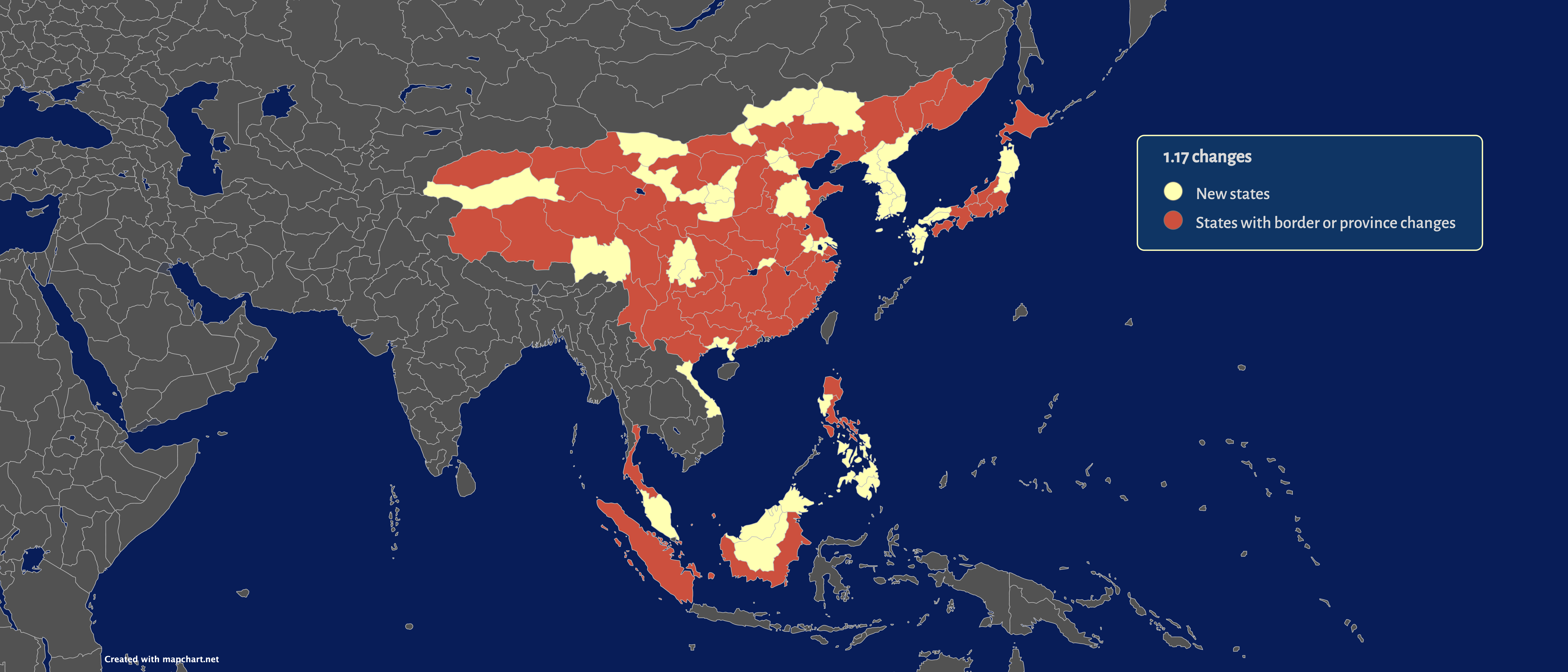
- The states map now has 1046 total states. The provinces map has 10,113 provinces.
- You can still select the game version (1.17, 1.16, 1.15, 1.14 or 1.13) for the map.
Version 7.0.1 - 2 Jan 2026
- Fixed minor issues with the Europa Universalis V (Locations) and (Provinces) maps.
Version 7.0.0 - 1 Jan 2026
-
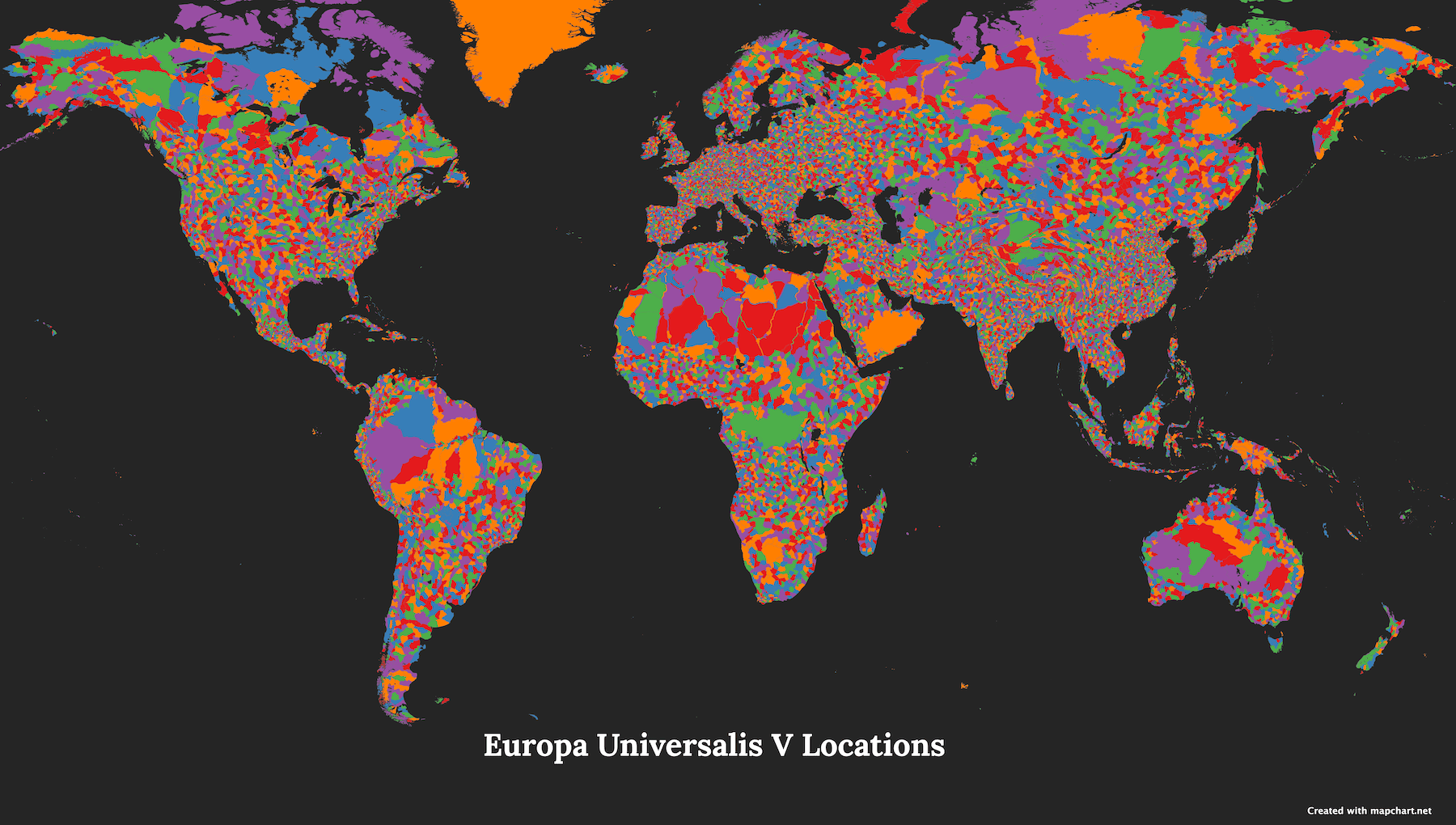
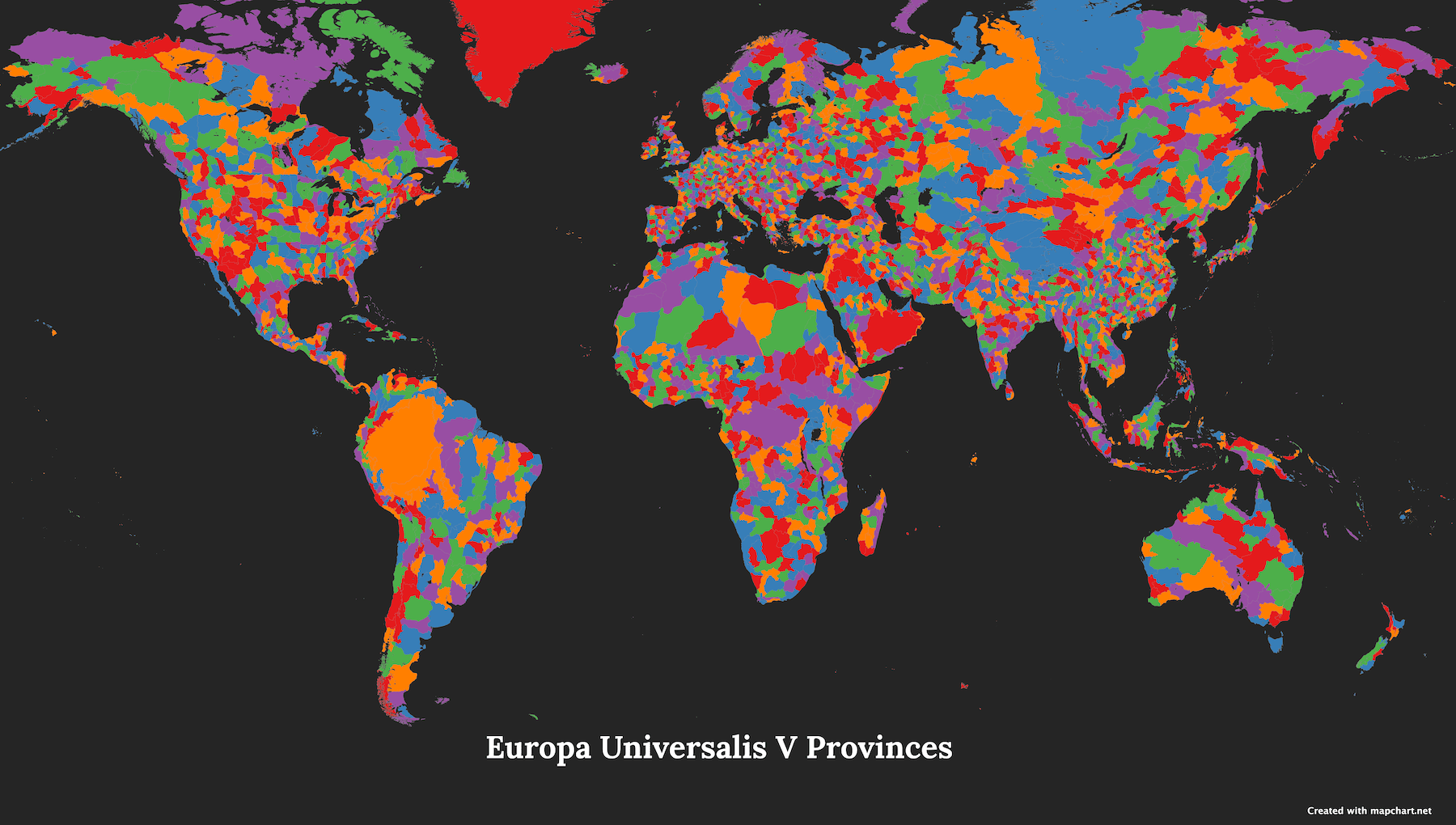
NEW! The Europa Universalis V (Provinces) and Europa Universalis V (Locations) maps are now up and ready for you to dive into! Notes:
- The provinces map has over 3,000 provinces and the locations map has over 22,000 locations.
- With so much detail, the locations map might slow down your device or even make your browser crash if it gets overwhelmed. So, take it slow and see how it goes.
- To improve performance, you can try:
- Zooming in and working on smaller sections at a time.
- Using a desktop with strong processing power and plenty of RAM.
- Closing any extra tabs to save resources.
- Switching off map borders to make it more responsive.
- If you're into crafting your own alternate history scenarios, the maps are your new best friends. Give them a try, and let's see the worlds you create!
-
Here is the Europa Universalis V (Locations) map ⬇️
-
Here is the Europa Universalis V (Provinces) map ⬇️
Version 6.11.3 - 17 Nov 2025
- Americas detailed: fixed borders of states around the Great Lakes in North America.
- Hearts of Iron IV maps: added states to the 1936 configuration (Republic of Syria, Lebanese Republic, Mandatory Palestine, Emirate of Transjordan, Sheikhdom of Kuwait, and Belgian Congo).
Version 6.11.2 - 14 Nov 2025
- Fixed an issue where Download process would fail on some devices.
Version 6.11.1 - 13 Nov 2025
- World subdivisions/Africa detailed: updated regions of Burundi 🇧🇮 (from 18 to 5) and added Ambatosoa region to Madagascar 🇲🇬.
- World subdivisions/Asia detailed: South Korea 🇰🇷 - fixed borders and shape of Busan, Daegu, and Gwangju metropolitan cities.
- Russia 🇷🇺: fixed islands in Sakhalin, Chukotka, and Kamchatka.
- World 1815 and World 1880 maps: Taiwan island is now displayed as part of China (Qing dynasty).
- Wargames map: added border between Denmark 🇩🇰 and Sweden 🇸🇪.
Version 6.11.0 - 12 Nov 2025
-
NEW! USA and Canada map: you can now split the states into smaller parts, similar to the USA states map.
- Right-click on a state and select Split state into parts .
- Examples include splitting California into Northern/Southern, splitting Pennsylvania into Eastern/Western, etc.
- To go back, right-click on a state part and select Show state as a whole or use the Undo button.
Version 6.10.9 - 12 Nov 2025
- [Plus] Simplified the UI for logging in.
- Minor design tweaks here and there.
Version 6.10.8 - 27 Sep 2025
- Fixed an issue where counting the number of paths in a subdivision group would not work properly.
Version 6.10.7 - 16 Sep 2025
- USA states map: you can now split Wisconsin in northern and southern parts.
- Fixed an issue where Brunei 🇧🇳 was not selected when coloring ASEAN countries.
Version 6.10.6 - 15 Sep 2025
- Americas detailed: swapped the names of Upper Takutu-Upper Essequibo and Upper Demerara-Berbice in Guyana 🇬🇾.
- Fixed some issues with the default configuration for the World subdivisions map.
Version 6.10.5 - 4 Sep 2025
- Asia detailed/World Subdivisions: Vietnam's 🇻🇳 provinces have been updated to match the 2025 changes. It's previous 65 provinces have been merged into 34 provinces.
- Hearts of Iron IV maps: fixed an issue with the borders between Cambodia and Southern Indochina.
Version 6.10.4 - 4 Aug 2025
- France departments map: added prefecture names for Pau, Auch, Agen, Montauban, and Albi.
Version 6.10.3 - 16 Jul 2025
- Fixes to the World Cold War map:
- Added major lakes to the map.
- Improved the display of each country's start/end dates when you hover over it.
- Improved Greenland's details.
- Added correct dates of Yugoslavian countries independence. Also added FRY from 1992 to 2003.
- The map now displays the Saar Protectorate (1947-1956).
- Added Sultanate of Zanzibar (1946-1962).
- Added correct dates and names for Yemen: Mutawakkilite Kingdom of Yemen > Yemen Arab Republic > Yemen and Aden Protectorate > People's Republic of South Yemen > People's Democratic Republic of Yemen > Yemen.
- Added correct dates and names for DR Congo: Belgian Congo > Republic of the Congo (Leopoldville) > Democratic Republic of the Congo > Zaire > DR Congo.
- Added Comoros and Seychelles pre-independence.
- USA historical map: improved the display of each state's start/end dates when you hover over the state.
Version 6.10.2 - 11 Jul 2025
- World subdivisions/Africa detailed: updated Angola's 🇦🇴 provinces:
- Added Icolo and Bengo and Moxico Leste provinces.
- Split Cuando Cubango into Cuando and Cubango provinces.
- Fixed borders of Lunda Norte, Lunda Sul, Malanje, Bengo, and Cuanza Norte provinces.
- Fixed an issue where the patterns were not displayed correctly on some maps.
Version 6.10.1 - 8 Jul 2025
- Brazil municipalities map: added the municipality of Boa Esperança do Norte in Mato Grosso.
- Fixed an issue where the label names font picker didn't display correctly.
- Mexico municipalities map: fixed the position of Tecomán and Manzanillo labels.
- Victoria 3 provinces map: fixed the state borders for some islands.
Version 6.10.0 - 27 Jun 2025
-
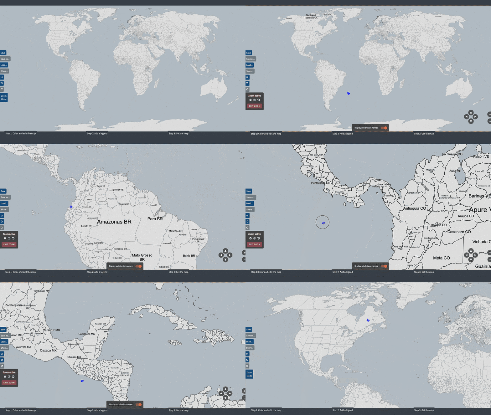
NEW! You can now display subdivision names while zooming to help navigate complex maps. Labels:
- Appear automatically as you zoom in.
- Work as a temporary visual aid.
- Are not available on maps that already have built-in labeling options in Step 1.
- To try it: Turn on Display names at the bottom of the map and zoom in.
-
Here is how it works ⬇️
- Fixed some issues with the name tooltips.
- Various UI improvements.
Version 6.9.1 - 16 Jun 2025
- Fixed an issue with the Pick a color tool not working correctly.
- Improved the performance of the Pick a color tool.
Version 6.9.0 - 12 Jun 2025
- [Plus] Updated the design and functionality of the My Maps page.
- [Plus] Updated the design and functionality of the Load saved map dialog.
Version 6.8.3 - 10 Jun 2025
- World 1880 map: fixed Hawaii being part of the United States.
Version 6.8.2 - 25 May 2025
- Indonesia 🇮🇩 map: fixed the borders of all West Papua regencies.
- Minor performance improvements.
Version 6.8.1 - 20 May 2025
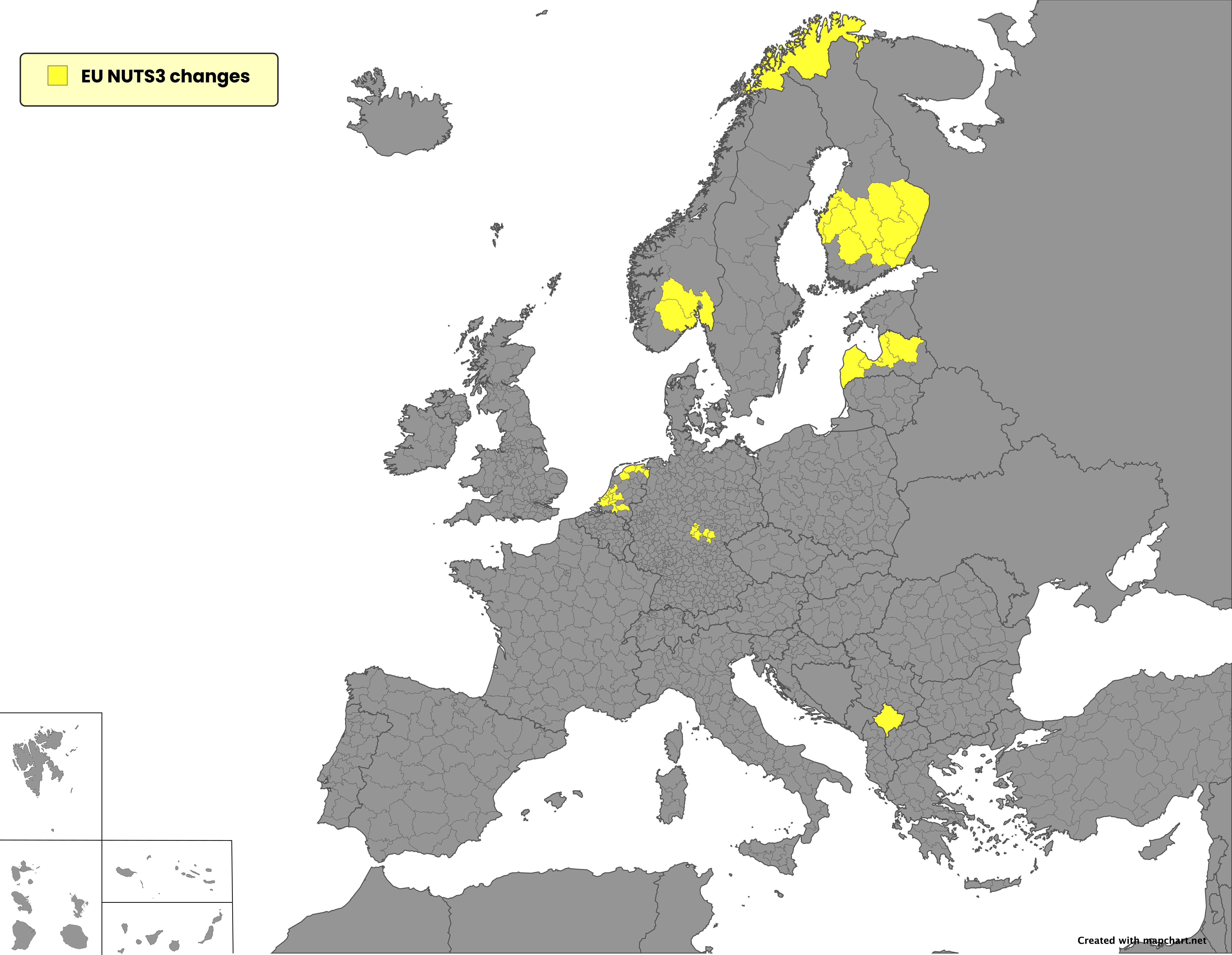
- Update to the European Union 🇪🇺 NUTS2 and NUTS3 maps to include the 2024 changes:
- European Union 🇪🇺 NUTS2: added Kosovo 🇽🇰 statistical regions, fixes in Netherlands 🇳🇱.
- European Union 🇪🇺 NUTS3: added Kosovo 🇽🇰 statistical regions, fixes in Netherlands 🇳🇱, Finland 🇫🇮, Latvia 🇱🇻, Germany 🇩🇪, and Norway 🇳🇴.
-
Here is a map displaying all the changes ⬇️
Version 6.8.0 - 12 May 2025
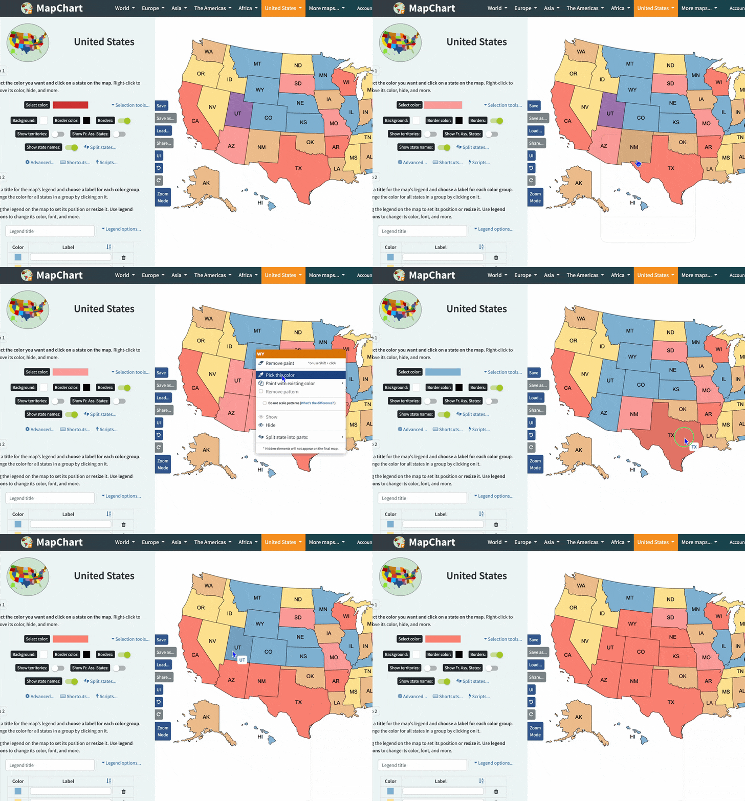
- New feature: you can now right-click on a country/state and select Pick this color to copy its color and use it immediately.
See how it works ⬇️
- Fixed an issue where configuration files with custom legend size would not apply the custom size.
- Fixed some other issues with the right-click context menu.
- You can now add up to 90 custom colors to the color picker. They are also groupped properly.
- [Plus] Fixed a longstanding issue with some accounts getting marked as expired in error.
Version 6.7.3 - 5 May 2025
- Minor fixes for the updated Hearts of Iron IV maps:
- Added a second province for Luxembourg.
- Fixed size of Musandam.
- Fixed state borders of Burgenland.
- Fixed state borders of Debar and Macedonia.
Version 6.7.2 - 3 May 2025
-
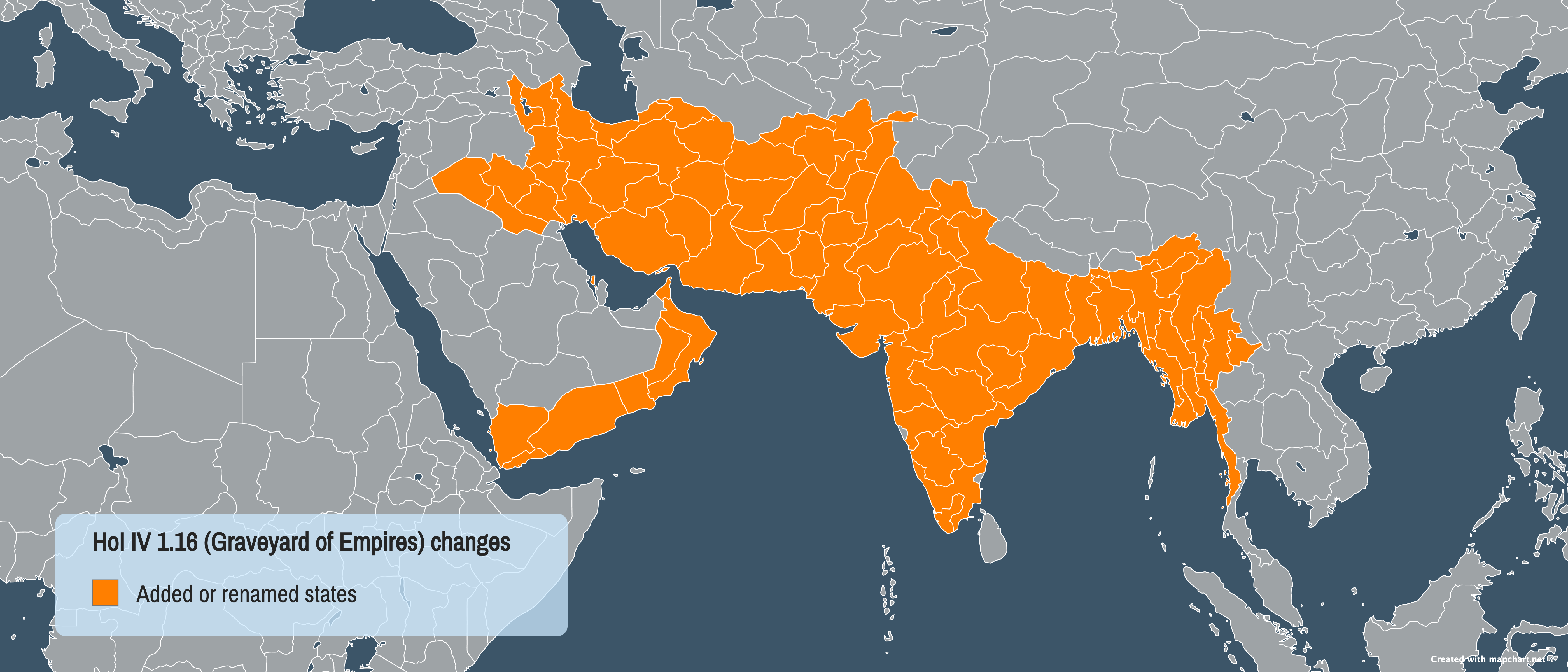
UPD The Hearts of Iron IV States and Hearts of Iron IV Provinces maps have been updated to the latest version of the game (version 1.16, Graveyard of Empires). Notes:
- Added new states or changed names of: Farah, Maymanah, Qataghan, Khyber Pass, Qandahar, Arakan, Magwe, Sagaing, Federated Shan States, Kentung and Yawnghwe, Irrawaddy, Pegu, Tenasserim, South Baluchistan, North Baluchistan, Kalat, Sibi, Waziristan, West Punjab, Bahawalpur, East Punjab, United Provinces, Gwalior, Central India, Central Provinces, Bastar, Kolhapur and Deccan, Northern Madras, Southern Madras, Madras States, Manipur, Sikkim, Province of Aden, South Khorasan, Yazd, North Khorasan, West Azerbaijan, East Azerbaijan, Ilam, Al Basrah, Al Anbar, Muscat, Musandam, Dhofar, South Yemen, Bahrain,North Yemen.
- Slight changes in some province borders in India and Burgenland.
-
Here is a map displaying all the changes ⬇️
- The states map now has 1016 total states. The provinces one is unchanged.
- You can still select the game version (1.16, 1.15, 1.14 or 1.13) for the map.
Version 6.7.1 - 29 Apr 2025
- World subdivisions/Asia detailed: renamed Tajikistan 🇹🇯 regions Leninabad to Sughd and Tadzhikistan Territories to Districts under Republic Subordination.
- Hearts of Iron IV: swapped positions of Oberösterreich and Niederösterreich in Austria.
- Victoria 3 provinces: fixed state borders in Azerbaijan.
- Mexico: added Lake Chapala outline to state borders.
- World 1914: fixed borders of Bulgaria.
- Fixed an issue with the legend background color picker not working when using the custom color option with a transparent color.
Version 6.7.0 - 25 Apr 2025
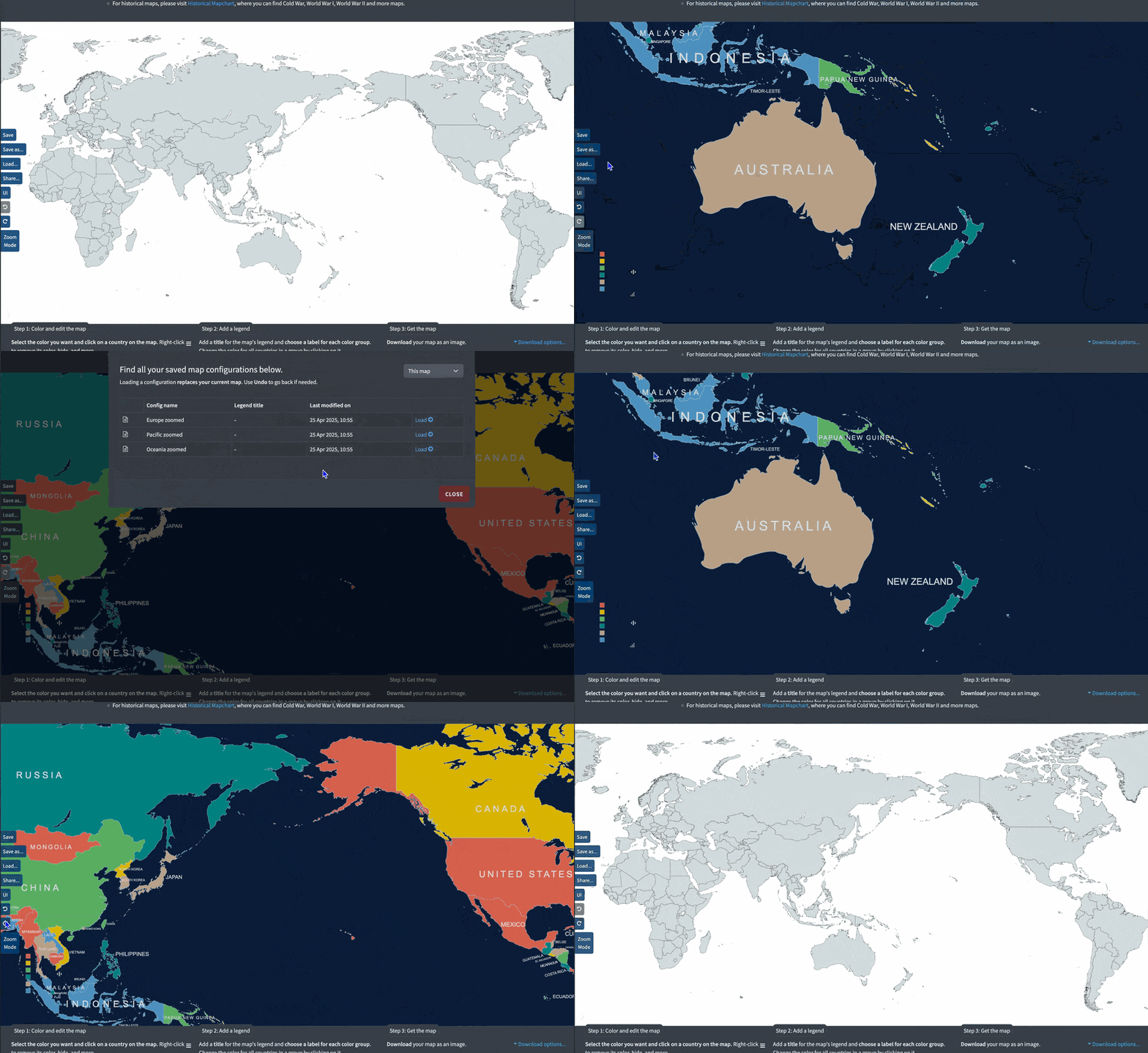
- Map zoom state (position and scale) is now saved in map configurations and restored when loading them.
See how it works ⬇️
- World subdivisions: fixed position of Gibraltar.
Version 6.6.7 - 23 Apr 2025
- Europe detailed/World subdivisions: updates and fixes for England 🏴 subdivisions (unitary authorities):
- Renamed Durham to County Durham.
- Added new unitary authority Halton.
- Combined Bournemouth, Christchurch, and Poole into Bournemouth, Christchurch and Poole.
- Split Bedfordshire into Bedford, Central Bedfordshire, and Luton.
- Split Northamptonshire into North Northamptonshire and West Northamptonshire.
- Split Cheshire into Cheshire East, Cheshire West and Chester, Halton, and Warrington.
- Split Cumbria into Cumberland and Westmorland and Furness.
Version 6.6.6 - 20 Apr 2025
- World subdivisions/Asia detailed: fixed borders of Oman governorates.
- Americas detailed: show St Barthelemy when isolating the Caribbean.
- Americas detailed: fixed Carriacou and Petite Martinique (Grenada) naming.
- Americas detailed: fixed names of Bermuda parishes and municipalities (City of Hamilton, City of Saint George, Devonshire, Hamilton, Paget, Pembroke, Saint George's, Sandys, Smith's, Southampton, Warwick) and other territories (Saint Pierre PM, Navassa Island UM).
Version 6.6.5 - 16 Apr 2025
- Europe detailed/World subdivisions: fixed borders between Zeta and Tuzi in Montenegro.
- Indonesia: renamed "Maluku Tenggara Barat" to "Kabupaten Kepulauan Tanimbar" and "North Mamuju Regency" to "Pasangkayu Regency".
- Africa detailed/World subdivisions: added Ouham-Fafa to CAR prefectures.
- Mexico municipalities map: renamed "Solidaridad_ROO" to "Playa_del_Carmen_ROO" and added Lake Chapala to the map.
- Asia detailed: updated Côn Đảo to be part of Bà Rịa – Vũng Tàu province in Vietnam.
Version 6.6.4 - 15 Mar 2025
- Improved the way the legend text is wrapped to fit within the legend column. This may slightly affect the legend layout, so if you notice any issues, please let me know!
- You can now split the legend into more columns (up to 4). This is available in the Legend Options... menu.
- Various fixes and optimizations.
Version 6.6.3 - 13 Mar 2025
-
UPD! The Australia electoral divisions map 🇦🇺 has been updated with the 2024 federal redistribution boundaries:
- Map is now valid for the upcoming 2025 federal elections (48th Australian Parliament).
- Redistribution has taken place for New South Wales, Victoria, and Western Australia. Check out more here.
- You can find the previous version of the map via the Select Election option on the page.
- World subdivisions: fixed the default configuration file with the latest updates.
- Africa detailed: fixed an issue where Bamako in Mali 🇲🇱 was not colored correctly when using Scripts .
Version 6.6.2 - 26 Feb 2025
- [Plus] Fixed an issue with the delete config button not working.
- Various styling updates.
Version 6.6.1 - 25 Feb 2025
- Europe detailed/World Subdivisions: fixed Haskovo and various border issues in Bulgaria 🇧🇬.
- Americas map: fixed an issue where Anguilla, Saint Barthélemy, Saint Martin, Sint Maarten, Saint Vincent and the Grenadines & the US Virgin Islands were not considered part of North America.
- World map: fixed an issue where part of Virginia was in Maryland, when toggling on the US states.
- World Subdivisions: fixed an issue with Bamako in Mali 🇲🇱 not being displayed correctly.
Version 6.6.0 - 21 Feb 2025
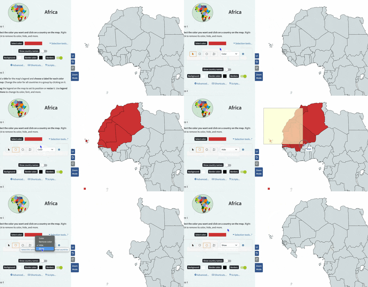
-
NEW! You can now remove the color, hide, or show the selected countries/subdivisions when using the
Rectangle,
Ellipse, and
Polygon selection tools.
See how it works ⬇️
- Fixed an issue with the side maps color when transparent background is selected.
- World subdivisions/Europe detailed: updated the subdivisions of Luxembourg 🇱🇺 to display its 12 cantons instead of its 3 regions.
Version 6.5.0 - 18 Feb 2025
- US Counties map: you can now display the county equivalents of US territories on the map:
- Find the new option in Step 1.
- Turn it on to display a sidemap of county equivalents for Puerto Rico, Guam, American Samoa, the US Virgin Islands, and the Northern Mariana Islands.
- You can also isolate each territory to create, for example, a map of Puerto Rico's municipalities.
- The Excel tools have been updated to include the county equivalents for these territories.
- The Random Color Scripts now feature a color picker so you can choose the colors you want to use (max 25). This means you can also use patterns for the random coloring.
- World subdivisions/Americas detailed: merged Eastern and Western Tobago to Tobago.
Version 6.4.4 - 11 Feb 2025
- Fixed an issue with some color pickers appearing cut off when opened.
- Fixed an issue with the custom color input field in some color pickers not being editable.
Version 6.4.3 - 7 Feb 2025
- Fixed an issue with the selection tools not working.
- Fixed an issue with Victoria 3 provinces map not loading sometimes.
Version 6.4.2 - 6 Feb 2025
- Fixed an issue with the image format preference not working for JPEG and SVG formats.
- Fixed an issue with the site not loading on iOS Chrome.
Version 6.4.0 - 5 Feb 2025
- Minor styling updates throughout the site. If you notice any issues, please let me know!
- Fixed an issue with uploading a config that contains color hex strings in uppercase format.
- UK elections map: fixed an issue with the previous map not loading.
Version 6.3.3 - 27 Jan 2025
- Europe NUTS2 and NUTS3 maps: updated Portugal's 🇵🇹 regions with the latest changes (NUTS2 source, NUTS3 source).
- World subdivisions/Africa detailed: added Songwe region to Tanzania 🇹🇿.
- World subdivisions/Africa detailed: added South Ethiopia Regional State and Central Ethiopia Regional State to Ethiopia 🇪🇹.
Version 6.3.2 - 24 Jan 2025
- World subdivisions/Africa detailed: updated regions of Mali 🇲🇱 (from 11 to 20).
Version 6.3.1 - 22 Jan 2025
- US states: added the ability to split Minnesota into northern and southern parts.
- World maps: added Indonesia to BRICS group.
- US congressional districts: fixed an issue with some small islands off the coast of New York.
- EU NUTS maps: fixed an issue where isolating multiple countries would not work.
Version 6.3.0 - 6 Jan 2025
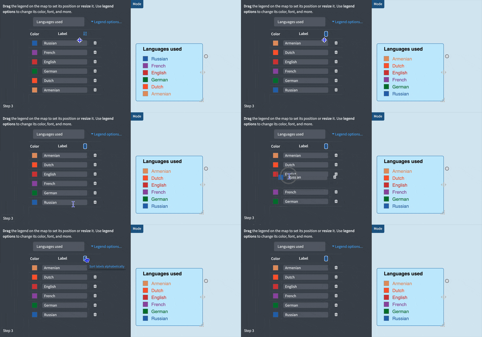
-
NEW! You can now sort the legend labels alphabetically.
See how it works ⬇️
- NEW! You can now use the ⚡️ Hide uncolored states/countries script to hide all uncolored states/countries on the map.
- Added the ability to search by subdivision for the Argentina 🇦🇷 and Indonesia 🇮🇩 maps.
- When you save the map's configuration, it now includes the page you're on (e.g. "usa-counties" or "hearts-of-iron-iv-provinces").
- Americas map: fixed an issue with the border between the United States and Canada (Haida Gwaii is part of Canada, not the United States).
- Europa Universalis IV map: renamed Ostrava to Hradiste and Burgas to Mesambria.
- Ukraine map: minor fixed to the borders of Kyiv.
Version 6.2.14 - 4 Jan 2025
- World maps: added Romania and Bulgaria to Schengen area countries.
Version 6.2.13 - 23 Dec 2024
- World subdivisions/Europe detailed: fixed borders of North Savonia, South Savonia and North Karelia in Finland 🇫🇮.
- World subdivisions/Asia detailed: added Arauto island to subdivisions of Timor-Leste 🇹🇱.
- World subdivisions: merged Las Palmas and Santa Cruz de Tenerife into Canary Islands in Spain 🇪🇸.
- Hearts of Iron IV States map: removed an invalid element named Zambia from the map.
Version 6.2.12 - 20 Dec 2024
- Fixed an issue with the map not displaying correctly on Safari older than version 16.4.
Version 6.2.11 - 19 Dec 2024
- US Counties map: added the ability to display the previous version of Connecticut counties in Step 1.
- Fixed an issue where the border width of US counties was too thick when isolated.
Version 6.2.10 - 16 Dec 2024
- UPD US counties map: updated Connecticut counties. More info here.
- World subdivisions/Asia detailed: renamed Đông_Bắc to Bắc_Kạn, Đồng_Bằng_Sông_Hồng to Hưng_Yên, Đông_Nam_Bộ to Đồng_Nai for Vietnam 🇻🇳.
- World subdivisions/Asia detailed: added Keserwan-Jbeil to Lebanon 🇱🇧.
- Added French Southern and Antarctic Lands to the Eurozone group.
- Historical world maps: fixed an issue with the border width of the United States.
- Hears of Iron IV States map: fixed an issue with some lines showing up in Tasmania.
Version 6.2.9 - 12 Dec 2024
- MapChart is now 10 years old! Read the blog post. Birthday month deal: MapChart Plus with 30% off!
Version 6.2.8 - 4 Dec 2024
- US Counties and US Congressional Districts maps: your choice of showing/hiding state abbreviations on the map will now be saved in your map configuration.
Version 6.2.7 - 3 Dec 2024
- BIRTHDAY MONTH DEAL! Get 30% off MapChart Plus.
- To celebrate MapChart's 10th birthday, we're offering a 30% discount on MapChart Plus for the month of December.
- The discount is valid for new subscriptions and all your future renewals!
Version 6.2.6 - 25 November 2024
- BLACK FRIDAY deal! Get 40% off MapChart Plus.
- The discount is valid for new subscriptions and all your future renewals!
- Offer will be available for the next few days.
Version 6.2.5 - 20 Nov 2024
-
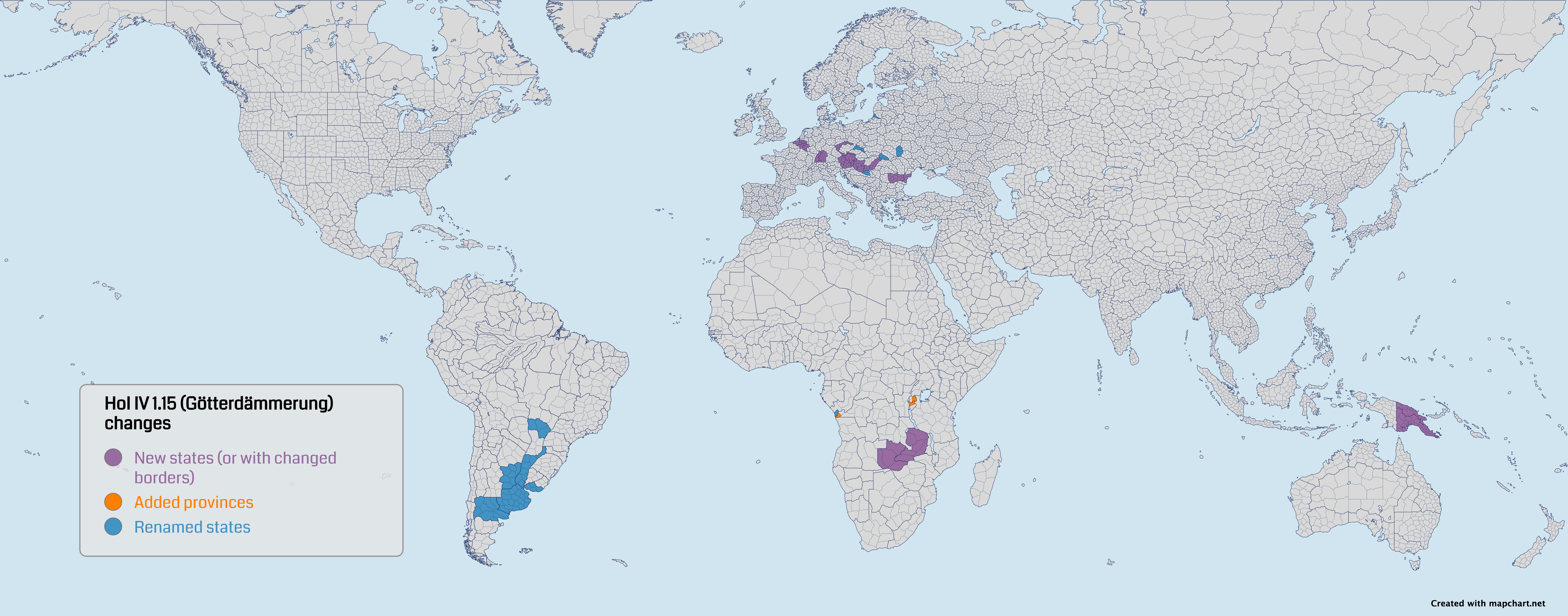
UPD The Hearts of Iron IV States and Hearts of Iron IV Provinces maps have been updated to the latest version of the game (version 1.15, Götterdämmerung). Notes:
- Added new states:Antwerpen, Ardennes, Baden, Burgenland, Oberösterreich, Niederösterreich, Steiermark-Kärnten, Bács-Kiskun, Tiszántúl, North/South Transdanubia, North/South Sudetenland, Northern Dobruja, Debar, Barotziland, Northeast Rhodesia, and Kaiser-Wilhelmsland.
- Renamed states: Backa (was Vojvodina), Proskuriv (was Khmelnytskyi), Buenos Aires (was Pampas), Montevideo (was Uruguay), Punta Porá (was Iguaçú), Región Mesopotámica (was Mesopotamia), Río Negro (was Patagonia), Podkarpatská Rus (was Carpathian Ruthenia), Klaipeda (was Memel), Cabinda (was North Angola), Czeské Slezsko (was Eastern Sudetenland), Tešínsko (was Zaolzie).
- Added new provinces to Rwanda, Burundi, and Leopoldville.
-
Here is a map displaying all the changes ⬇️
- The states map now has 982 total states and the provinces one 10,106 provinces.
- You can still select the game version (1.15, 1.14 or 1.13) for the map.
Version 6.2.4 - 1 Nov 2024
-
UPD! The Canada federal ridings map 🇨🇦 has been updated with the 2023 redistribution boundaries:
- Map is now valid for the upcoming 2025 federal elections (45th Canadian Parliament).
- There have been changes to almost all ridings. More on the 2022 redistribution page on Wikipedia.
- You can find the previous version of the map via the Select Election option on the page.
Version 6.2.3 - 31 Oct 2024
- [Plus] Fixed some issues with the My Maps page.
Version 6.2.2 - 18 Oct 2024
- Fixed an issue where downloading the map image would not work on Safari versions before 16.4.
Version 6.2.1 - 17 Oct 2024
-
NEW You can now merge two map configurations together:
- After editing your map, go to Step 3 > Save/Load Map Configuration > Config tools.
- Upload the map configurations you want to merge together.
- Click the Merge Configurations button.
- A new map configuration will be made, combining all the elements from the two uploaded configurations.
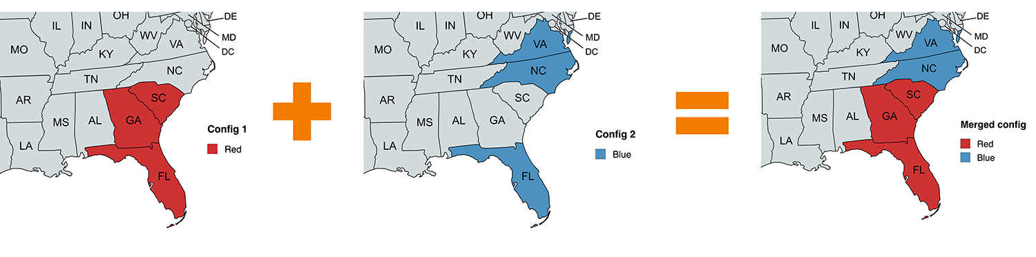
-
Example: Config 1 has FL, GA, and SC colored red. Config 2 has FL, NC, and VA colored blue. The result will have FL, GA, SC colored red, and NC and VA colored blue. ⬇️
- Fixed an issue with the legend position when uploading a map configuration.
Version 6.2.0 - 10 Oct 2024
-
NEW You can now export your map directly to the MapChart app 📲 :
- After editing your map, go to Step 3 > Save/Load Map Configuration > Export to app.
- Click the Generate QR Code button.
- Use one of these methods to scan the QR code:
- Open your device's camera and point it at the QR code.
- Or, in the app, go to My Maps and tap the button in the top right corner.
- The map will automatically load in the app.
- Don't have the app yet? Get it from the App Store or Google Play.
-
Here is a short video on how it works ⬇️
- You need the latest app version to use this feature (version 5.9.0 or later).
- [Plus] Changed the name of the config file when you save it to your account, to make it more readable. Now it's the map title you give it (or "Untitled" if you don't give it a name).
- World with microstates map: fixed an issue with the border width of some countries.
Version 6.1.10 - 6 Oct 2024
- UK historic counties: fixed border between Londonderry and Donegal.
- India: minor border fixes.
- World 1815, 1880, 1914 and 1938 maps: fixed the shape of the Great Lakes in North America.
Version 6.1.9 - 30 Sep 2024
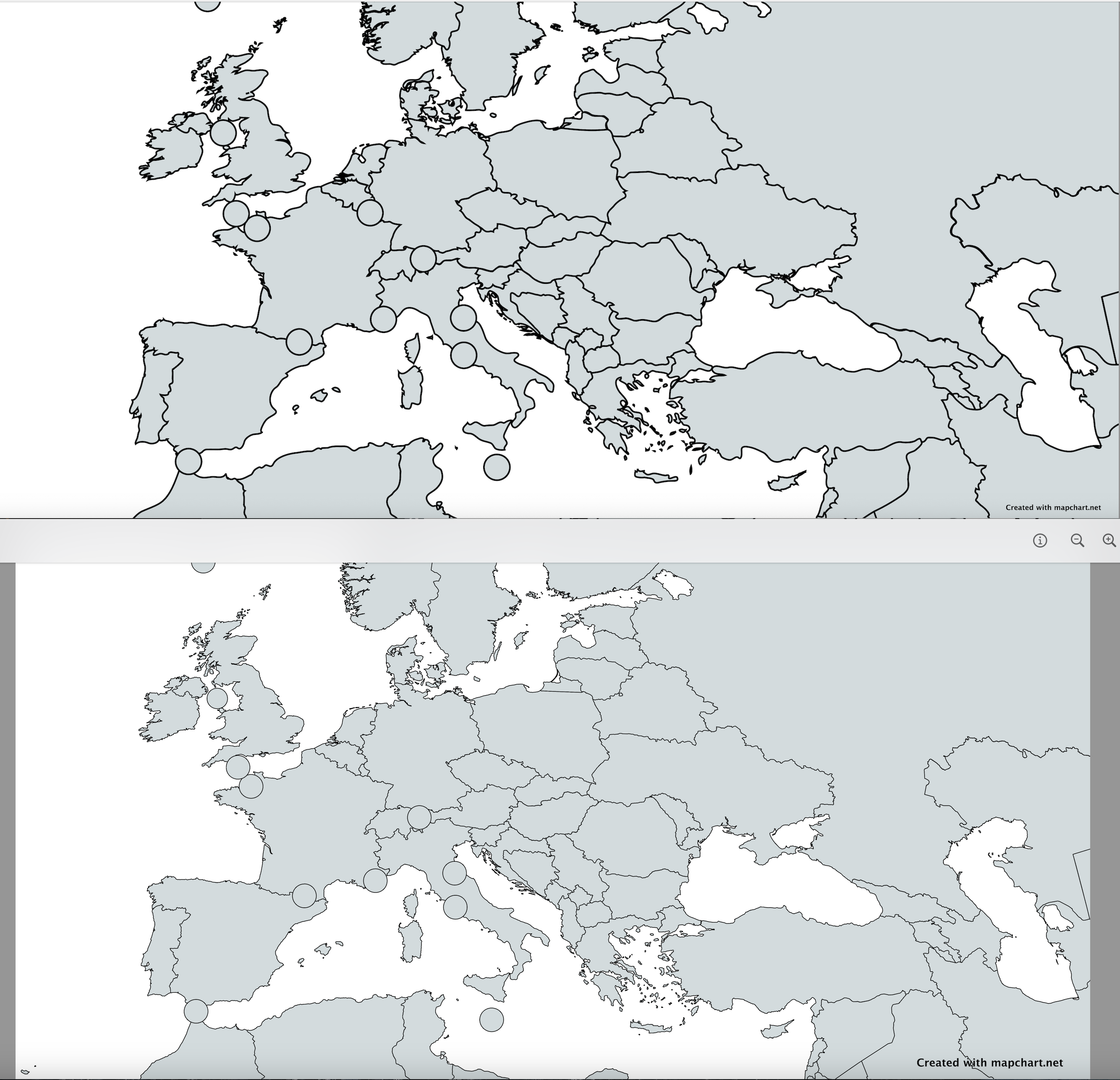
- World map with microstates: the map has been completely redone to improve its quality (more accurate country shapes, more details). Check it out here.
Before and after ⬇️
- World map with microstates: added the ability to split the United Kingdom into its constituent countries.
Version 6.1.8 - 26 Sep 2024
- Added the Mexico municipalities 🇲🇽 and Brazil municipalities 🇧🇷 maps to the Excel tool for MapChart. Tutorial on using the tool here.
Version 6.1.7 - 19 Sep 2024
- Mexico map 🇲🇽: added the ability to color all municipalities of a state at once, and the ability to search for a municipality.
Version 6.1.6 - 17 Sep 2024
- Italy map 🇮🇹: added the newly added provinces of Sardinia: Gallura Nord-Est Sardegna, Medio Campidano, Ogliastra, and Sulcis Iglesiente. Adjusted borders of the rest of the provinces.
Version 6.1.5 - 30 August 2024
- US Counties map: fixed an issue where, when isolating a state, the map would not zoom in and center on the state.
Version 6.1.4 - 28 August 2024
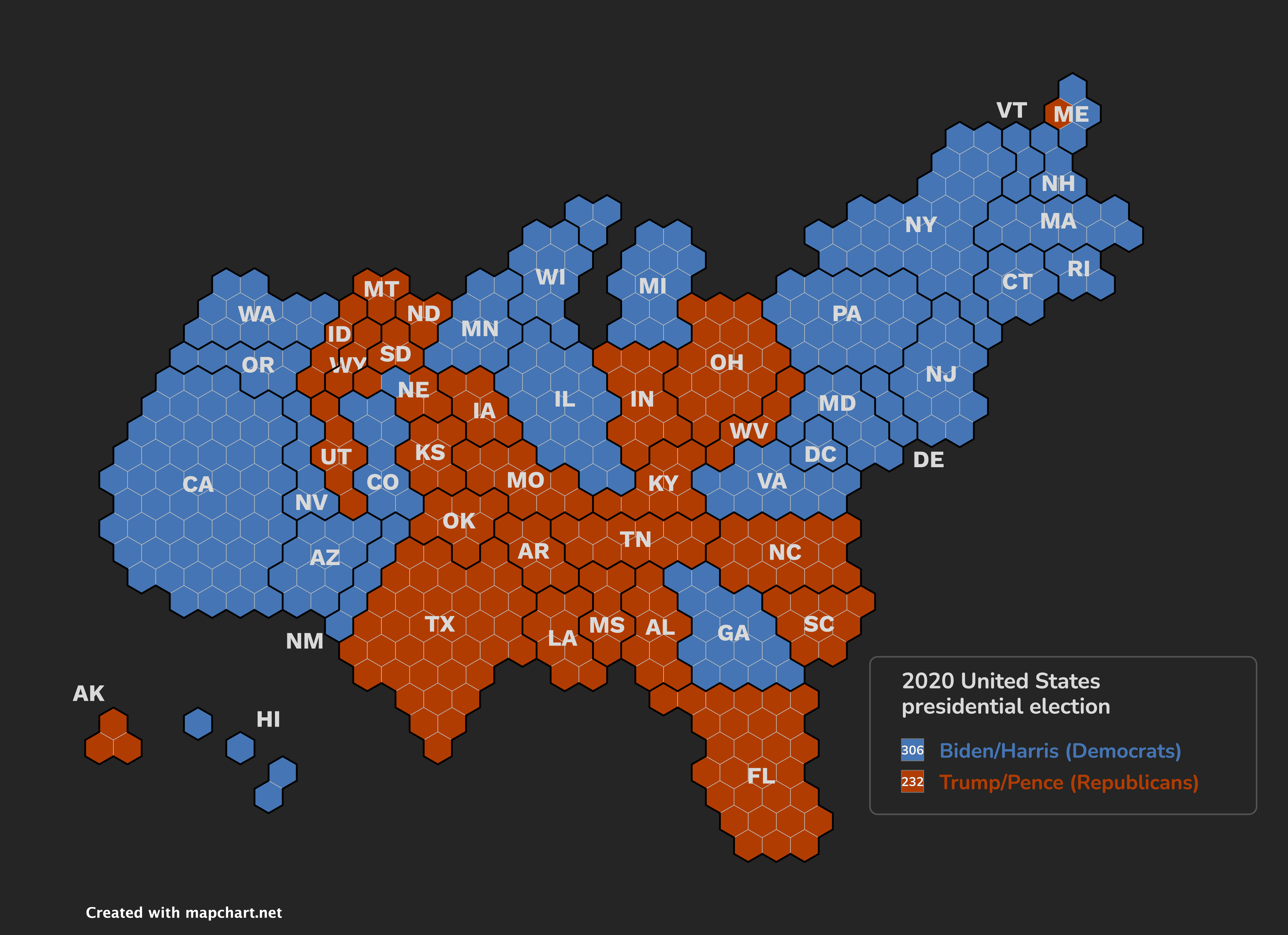
- USA Hex Cartogram map: you can now display the number of votes for each legend entry directly in the legend on the final map.
Example map ⬇️
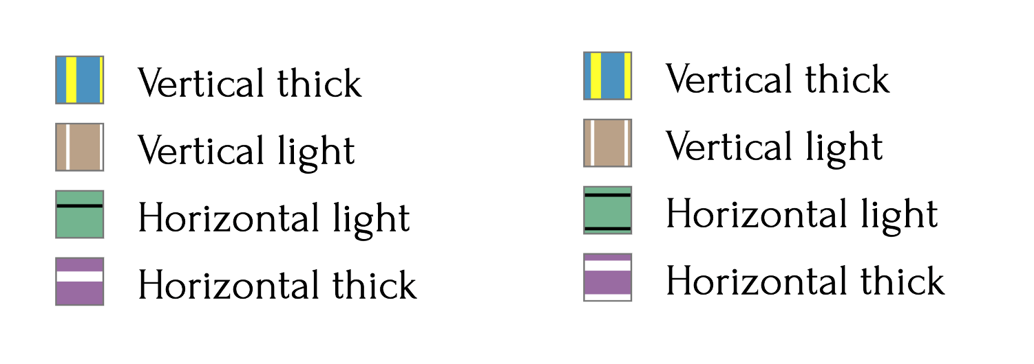
- Improved how vertical and horizontal patterns are displayed inside the final map's legend boxes.
Before and after for patterns ⬇️
- Fixed an issue where coloring an element, then coloring it with the default color, would break the legend colors structure.
- Fixed an issue where hiding an element with Shift-click, then coloring it again, would display a thinner version of its borders.
- Fixed an issue where trying to pick a color from a hidden element on the map would add an invalid element to the legend.
Version 6.1.3 - 26 August 2024
- Added the following municipalities to the Mexico map 🇲🇽:
- In Morelos: Coatetelco, Hueyapan, Xoxocotla.
- In Quintana Roo: Puerto Morelos.
- In Sinaloa: Juan José Ríos and Eldorado.
- In Guerrero: Las Vigas, Ñuu Savi, San Nicolás, and Santa Cruz del Rincón.
- In Baja California: San Felipe, San Quintín.
- In Chiapas: Capitán Luis Ángel Vidal, El Parral, Emiliano Zapata, Honduras de la Sierra, Mezcalapa, and Rincón Chamula San Pedro.
- World subdivisions/Africa detailed: fixed borders between Al Jizah (Giza) and Cairo governorates in Egypt 🇪🇬.
- World with microstates: fixed Phú Quốc not being part of Vietnam 🇻🇳.
- USA Hex Cartogram map: when using undo/redo, votes are also updated.
Version 6.1.2 - 17 August 2024
- Improvements to all color pickers:
- When selecting a custom color, you can now see a preview box for the color right below.
- You will now get notified if you try to input an invalid custom color.
- Selecting a custom color by moving in the spectrum box is now faster.
- USA Hex Cartogram map: when hovering over the map, you can now check out how many votes each state has.
Version 6.1.1 - 16 August 2024
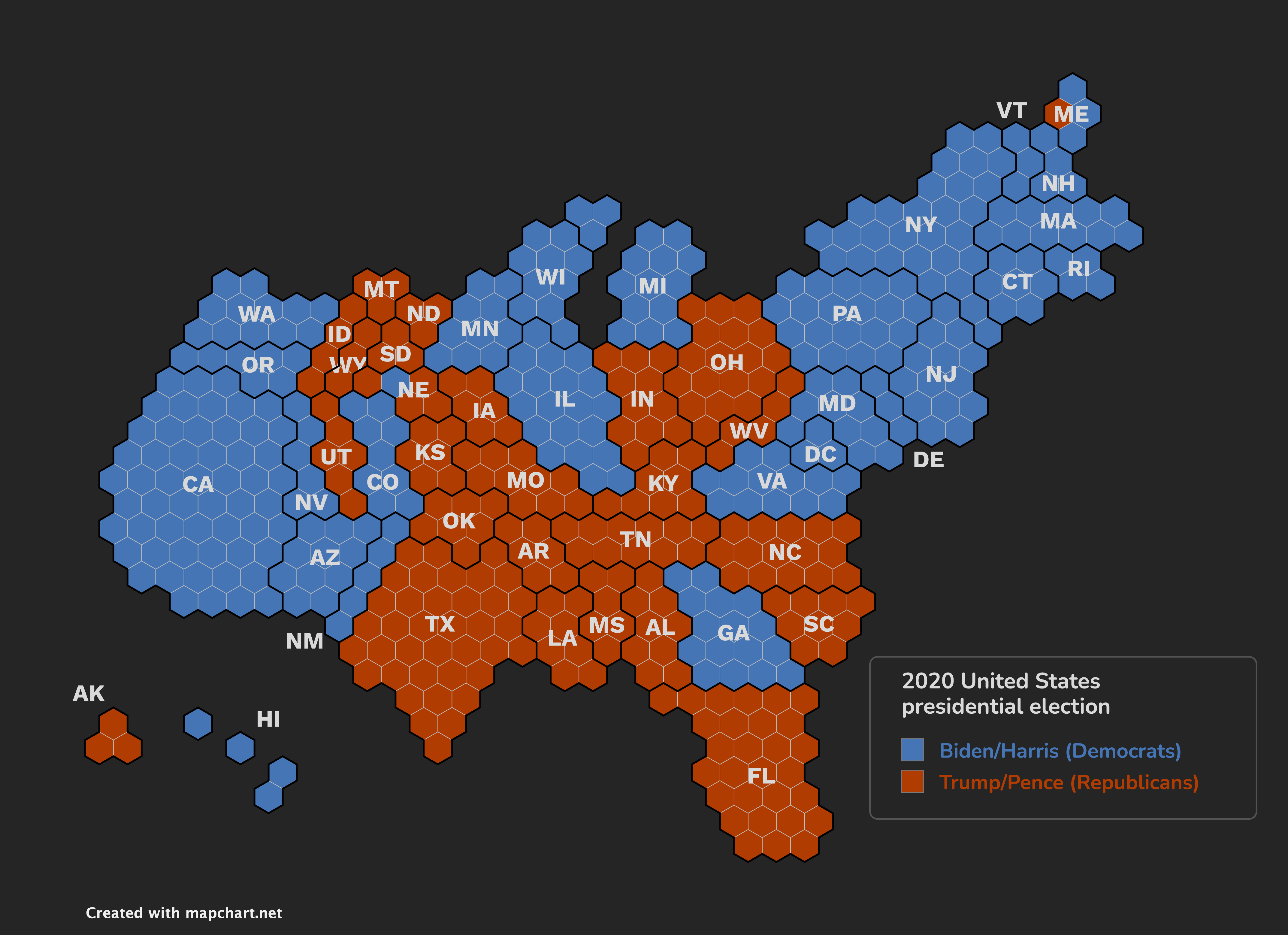
- USA Hex Cartogram map: you can now instantly load a starter map configuration with the election results of the 2012, 2016, and 2020 US Presidential elections.
-
Here is one of the maps ⬇️
- USA Counties map: you can now change the state labels font and color.
- US maps: when you change the labels color for state abbreviations, the state lines for RI, VT, NJ, DE, MD, DC, also change to the same color.
- Fixed an issue where holding Cmd/Ctrl and moving over the map didn't work.
Version 6.1.0 - 14 August 2024
- Improved the downloaded map quality when downloading as a PNG or JPEG image. The image you get is now more accurate and doesn't contain random artifacts when you remove element borders.
-
Here is a before/after (open in new tab to zoom in) ⬇️
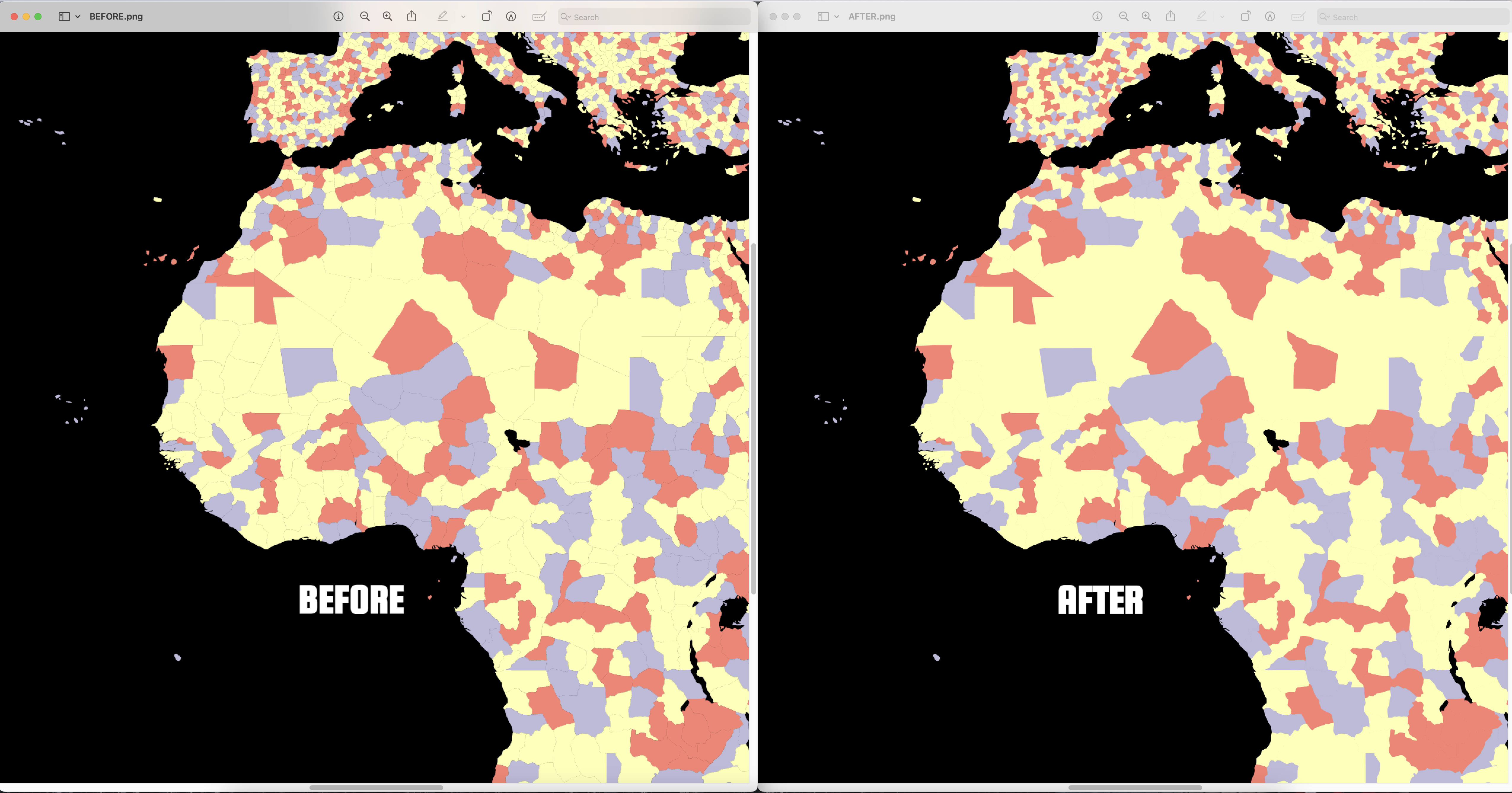
- USA Hex Cartogram map: fixed an issue where vote counts would not be accurate for the previous map version.
Version 6.0.11 - 8 August 2024
- Fixed a long-standing bug that caused invalid legend entries when hiding, coloring, and then undoing actions on map regions. 💣 🐛 ➡️ 💥
Version 6.0.10 - 5 August 2024
- USA Hex Cartogram map: votes are now updated on all map operations. Fixed an issue where vote counts would not display on the 2012-2020 version of the map.
- USA Counties map: added the ability to isolate District of Columbia.
- Fixed an issue with restoring a map on the simple World map.
- Hearts of Iron IV Provinces map: added Galicia_10 province.
Version 6.0.9 - 1 August 2024
- Hearts of Iron IV Provinces map: removed Armenia_10 and added Pamir_17 provinces.
Version 6.0.8 - 31 July 2024
- Fixed an issue with the undo/redo functionality when using the keyboard shortcuts.
- Fixed an issue with restoring a map with hidden countries on the simple World map.
- World subdivisions: fixed gaps around provinces in Asia.
Version 6.0.7 - 31 July 2024
- Fixed an issue with some pages failing to load.
- World/Asia/Europe/India/the Americas maps: fixed an issue where parts of name labels would not change color.
- Asia Detailed - World subdivisions: fixed borders of Siemréab province in Cambodia 🇰🇭.
- Europe Detailed - World subdivisions: added the municipality of Tišina to Slovenia 🇸🇮.
- Tamriel: fixed name of Haafingar.
Version 6.0.6 - 16 July 2024
- Improved legend resizing when the legend is on the right side.
- US Counties map: when you isolate a state, it now zooms in properly to also include all county names on the map.
- Victoria 3 maps:
- Added Urmia as a state.
- Fixed an issue with Azerbaijan's borders.
- Hearts of Iron IV provinces: added Leon_07 and Armenia_10 provinces.
Version 6.0.5 - 13 July 2024
-
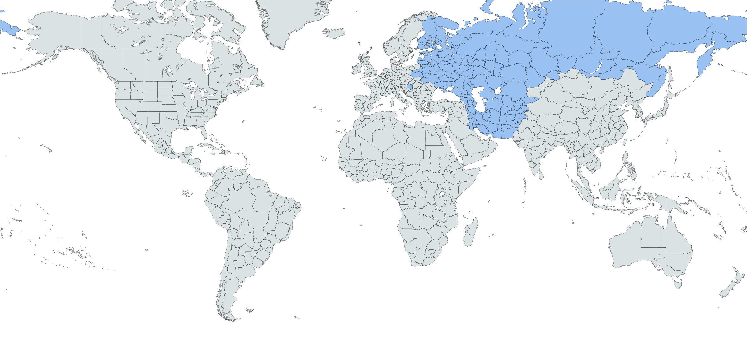
UPD The Victoria 3 States and Victoria 3 Provinces maps have been updated to the latest version of the game (version 1.7 "Sphere of Influence"). Notes:
- Added new states and their provinces and changed shapes of existing ones in Eurasia. Almost 1/3 of the map has changed.
-
Here is a map displaying all the changes ⬇️
- The states map now has 659 total states and the provinces one 40,696 provinces.
- You can now select the game version (1.7 or 1.5 for now) for the map.
- Fixed an issue where, in Safari, hovering over the map didn't highlight countries/states.
Version 6.0.4 - 10 July 2024
- Hearts of Iron IV maps:
- Added Hubei 13 and Brittany 04 provinces.
- Fixed an issue where, when loading the 1936 configuration, Haida Gwaii was displayed as part of the United States.
- Fixed an issue with the placement of Easter Island.
- World map (simple): fixed an issue with Scotland's borders.
- Mexico: added Dzitbalché and Seybaplaya municipalities.
- UK Elections map: fixed an issue where search didn't work properly when changing the map version.
- World 1815 map: split the Kingdom of Two Sicilies into the Kingdom of Naples and Kingdom of Sicily.
- When you try to color the Caribbean region (e.g. on the detailed Americas map), it now correctly colors all smaller island countries.
- Fixed an issue where sometimes the legend got stuck at the edge of the map.
Version 6.0.3 - 9 July 2024
-
UPD The US Congressional Districts map has been updated with all the redistricting changes for the upcoming 2024 Congressional elections (119th Congress):
- New York, Alabama, Louisiana, Georgia, and North Carolina have redrawn their districts. More info on redistricting.
- The current map is valid for the upcoming 2024 elections, for the 119th Congress (from Jan 3, 2025 to Jan 2, 2027).
- You can find the previous (118th and 117th Congress) maps, via the Select Congress option on the page.
- Fixed an issue where Alabama's newer districts were displayed on the previous map for the 118th Congress.
- The Excel tools have also been updated.
- Ukraine map: fixed an issue where Crimea oblast could not be clicked.
- Fixed issues with border thickness in Europe map.
- Fixed an issue with white margins being displayed above and below maps.
Version 6.0.2 - 3 July 2024
- Hearts of Iron IV maps: removed a province from Cameroon and added it to Benue.
- Hearts of Iron IV Provinces: removed erroneous state borders in Murmansk, Burma, and Guanxi.
- Fixed issues with border thickness in Russia map, and the detailed Asia and Africa maps.
- Fixed an issue where right-clicking would also color the element underneath.
Version 6.0.1 - 2 July 2024
- Fixed an issue where clicking to change the color of a legend group at once would not work after the first change.
- Improvements to the color pickers: you can now always see which colors you have currently used.
- Fixed an issue with the right-click menu staying on top of the map even when clicking elsewhere.
Version 6.0.0 - 1 July 2024
MapChart version 6 is here! The map drawing engine has been improved, after noticing various performance and stability issues.
- This brings several benefits:
- 🪲 Stability: The maps should now work better on every device without issues.
- 🔍 Enhanced Zoom: Using the browser's page zoom is available again.
- 🔄 Consistency: All features added since version 5, like the new theme, legend customizations, labels font, etc., are integrated in the latest version.
- As with any change, there are a few things to note:
- ⚠️ Legend Adjustments: If you're uploading an older map configuration, you might need to tweak the legend's size and position. You can easily adjust and save your map again.
- 🐛 Bug Reporting: If you encounter any issues, please use the Report a bug 🪲 button or visit the Feedback page. Your input helps us improve quickly.
Version 5.4.9 - 10 June 2024
- US states: added the ability to split Indiana in eastern and western parts.
- Asia detailed/World subdivisions: split Surigao del Norte to add Dinagat Islands in the Philippines 🇵🇭.
- Asia detailed/World subdivisions: split Maguinadanao in half (Maguindanao del Sur and Maguindanao del Norte) in the Philippines 🇵🇭.
- Europe detailed/World subdivisions: display Arran island as part of North Ayrshire in Scotland 🏴.
Version 5.4.8 - 27 May 2024
- Hearts of Iron maps:
- NEW You can now automatically color the map with the initial setup of countries in the game, in 1936. Find the option to do this in the header of the page.
- Fixed a state border issue in Southen Slovakia.
- Fixed name of Iguaco to Punta Porá.
- Africa detailed: added Cabo Verde 🇨🇻 subdivisions to the map.
- World Cold War: fixed an issue with Palestine in 1946-1947.
- World subdivisions: fixed gaps in Lebanon's subdivisions 🇱🇧.
- Fixed an issue with the color of the tooltip, after picking a color from the map.
- Europe NUTS2: fixed an extra element above Syria.
Version 5.4.7 - 7 May 2024
- Hearts of Iron IV Provinces: fixed a state border issue in Stalinabad.
- Europe NUTS2 and NUTS3: added the state border outline of Mount Athos and Crown dependencies. Fixed border width of state borders.
Version 5.4.6 - 30 April 2024
- Fixed an issue where, when using a transparent background color, hidden countries would glitch.
- World subdivisions: fixed an issue with Lithuanian counties borders.
- Europe WWI map: fixed borders between Belgium and Germany.
- Hearts of Iron IV Provinces: removed an extra province from the Amazonas.
Version 5.4.5 - 23 April 2024
- USA Historical and World Cold War maps: when saving a map configuration, the selected year is now also saved.
- World with microstates: fixed an issue with the labels of India and Malaysia.
- World subdivisions: fixed an issue with the name of Bayan-Ölgii.
- World map: fixed borders between California and Arizona when Show US States is active.
- Victoria 3 maps: renamed Circars state and provinces to Andhra.
Version 5.4.4 - 3 April 2024
- Fixed an issue with downloading the map not working on iOS Safari browsers.
- US Congressional Districts: fixed an issue with AL06 district's border width.
- UK & Ireland Counties map: fixed border gaps.
Version 5.4.3 - 31 March 2024
- Hearts of Iron IV Provinces: added provinces that were recently updated with version 1.14 of the game:
- Added Fars 10 (island off the coast of Iran).
- Split Falkland Islands into two provinces.
- Added Chubut 07 (island off the coast of Argentina).
- Added Araucanía 05 and Aysén 06 (islands off the coast of Chile).
- Added Districts of Ontario 05, Cote Nord 07, and Nord du Quebec 11 (in Canada).
- Split Qatar into two provinces.
- Split island from North Borneo 17 to become Kalimantan 44.
- Split island from Singapore 25 to become Sumatra 55.
- Fixed a line appearing over West Virginia.
- World subdivisions: name fixes (removed blanks) for Ysyk-Köl_KG, Bayan-Ölgii_MN, Bà_Rịa–Vũng_Tàu_VN, and Guyane_Française_GF.
Version 5.4.2 - 29 March 2024
- US Counties: fixed an issue where random numbers appeared in the Step 1 color/isolate tools.
- Europa Universalis IV map: swapped Rhade and Tay Nguyen.
- World 1938: fixed an issue with the Free City of Danzig not being displayed correctly.
Version 5.4.1 - 28 March 2024
- US Counties: you can now hover over a highway to check which highway it is.
- Hearts of Iron IV States: fixed borders in Nordland.
- Hearts of Iron IV Provinces: fixed an issue with a line appearing on top of the map.
- Advanced world maps: the previously erroneously named Indian Ocean Territory (Christmas Island) is now merged with Australia.
Version 5.4.0 - 26 March 2024
-
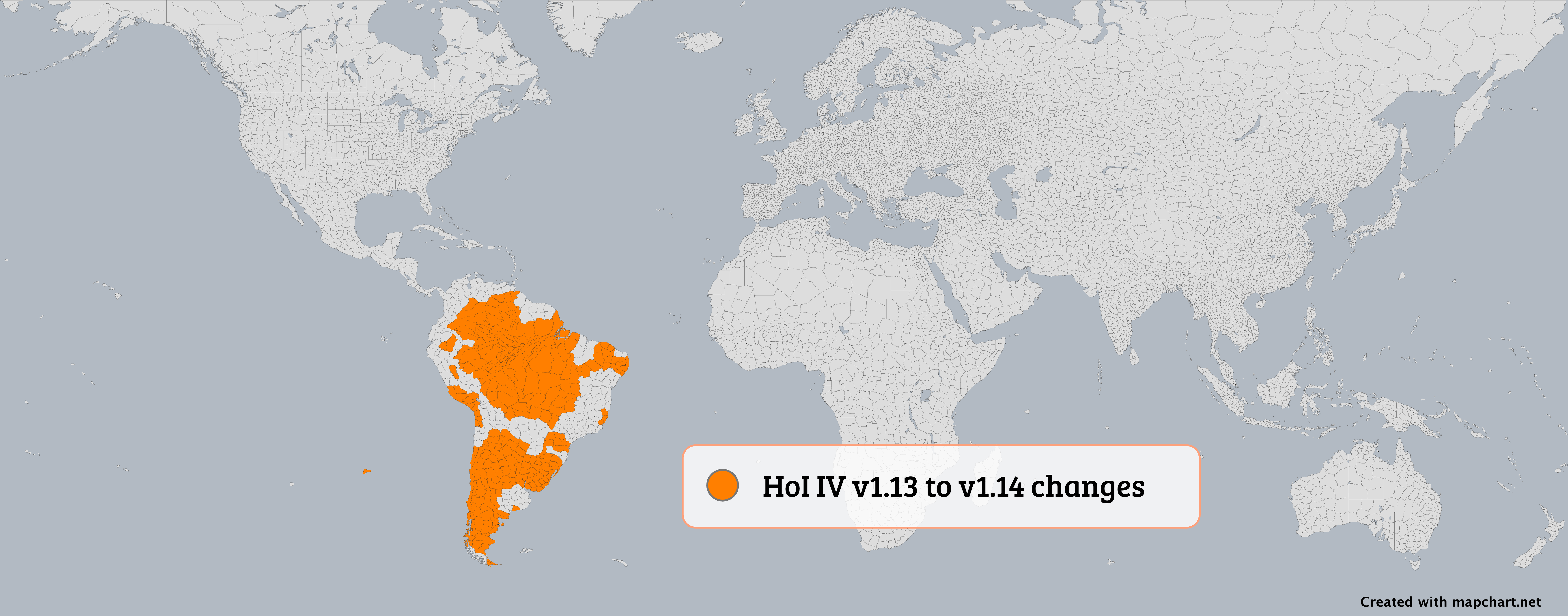
UPD The Hearts of Iron IV States and Hearts of Iron IV Provinces maps have been updated to the latest version of the game (version 1.14, Trial of Allegiance). Notes:
- Added states and their provinces in Latin America: Acre, Amapá, Amazon impassable 1-8, Araucanía, Arica y Tarapacá, Atacama, Aysén, Ceará, Cerro Largo, Chaco_Austral, Chubut, Easter Island, Espírito Santo, Formosa, Guaporé, Los Andes, Mato Grosso, Minas Gerais, Pará, Paraná, Paysandú, Pernambuco, Piauí, Región_Mesopotámica, Rio_Branco, Rio Grande do Norte, Río Negro, San Juan y La Rioja, San Luis y La Pampa, Santa Catarina, Santa Cruz AR, Tacna Moquegua, Tierra del Fuego, Tocantins, Tucumán.
- Changed borders in adjacent states to the newly added ones in Latin America.
-
Here is a map displaying all the changes ⬇️
- The states map now has 969 total states and the provinces one 10,103 provinces.
- You can now select the game version (1.14 or 1.13 for now) for the map.
- [Plus only] Fixed an issue with not being able to load historical maps from the My Maps page.
- UK election map: fixed shape of Clacton.
- Fixed an issue with the "Color all subdivisions of an element" feature.
Version 5.3.1 - 24 March 2024
- EU NUTS 3 map: fixed some issues with erroneous subdivisions showing up.
Version 5.3.0 - 21 March 2024
-
UPD Updated the Europe NUTS2 and NUTS3 maps:
- The maps now include NUTS subdivisions for non-EU countries: Norway, Iceland, Switzerland, Serbia, Montenegro, North Macedonia, Türkiye, Albania, and Liechtenstein.
- Fixed all gaps between borders.
- For more info check Eurostat's website.
- Increased the frequency of autosaves to ensure progress is not lost in case of unexpected events.
- You can now customize what happens when you hold Control + Shift, and move your mouse over the map. You can set it to color, remove color, show/hide countries. Set it from the Advanced... dialog in Step 1.
Version 5.2.6 - 19 March 2024
- World Cold War: fixed borders between Serbia and Montenegro and Montenegro in 2005-2006.
- Fixed an issue where uploading the same configuration file more than one time would not work.
- Tamriel map: fixed (again) an issue with the borders of Alik'r Desert.
Version 5.2.5 - 14 March 2024
- World Cold War: fixed borders between Yugoslavia and Bosnia and Herzegovina in 1992.
- World Cold War: fixed borders between Israel and the Palestinian Territories from 2005 to 2016.
Version 5.2.4 - 11 March 2024
- Added Egypt 🇪🇬, Ethiopia 🇪🇹, Iran 🇮🇷, and the United Arab Emirates 🇦🇪 to BRICS countries in the Region selection feature of the world maps.
- World subdivisions: fixed an issue with the G7 not being able to color when using the Color Multiple feature.
- Brazil municipalities: fixed an issue with the Color Multiple feature.
Version 5.2.3 - 8 March 2024
- Added Sweden 🇸🇪 to NATO countries in the Region selection feature of the world maps.
Version 5.2.2 - 5 March 2024
- Fixed some issues with the placement of the "Created with mapchart.net" tag in the generated image on some devices.
- Fixed an issue with the My Palette page not loading properly.
- Tamriel map: fixed an issue with the borders of Alik'r Desert.
- Europe: Added Palestinian territories to the map.
- Various optimizations that should help with the initial loading of all pages.
Version 5.2.1 - 1 March 2024
- World 1815 fixes:
- Corrected borders between the United States, the Vice Royalty of New Spain, and British North America.
- Display the United Kingdom of Sweden and Norway.
- Fixed name of Santo Domingo.
- World 1880: Display Bioko island as Spanish colony.
Version 5.2.0 - 29 February 2024
-
UPD The Export to SVG option is back!
- You can now download your maps in SVG format again. Find it in Step 3 > Download options....
- Please note that there may be some inconsistencies when opening the SVG on different apps (Inkscape, Adobe Illustrator, etc.).
- If you notice anything weird, let me know!
- Fixed an issue with custom legend positions or sizes.
- Wargames world map: fixed an issue where Cote d'Ivoire wouldn't be colored when coloring multiple countries.
- Poland: fixed an issue with Elblag City.
Version 5.1.0 - 27 February 2024
-
UPD The UK election map has been fully updated to reflect the 2023 boundary review changes!
- There have been changes in almost all constituencies.
- The updated map no longer has gaps between subdivisions.
- It features a sidemap for the Greater London area.
- You can select to use the previous map, but please note that your data is not transferrable, i.e. switching maps will reset your current one.
- Fixed some issues with the placement of the "Created with mapchart.net" tag in the generated image.
- Victoria 3 Provinces: removed one province from North Island.
Version 5.0.13 - 20 February 2024
- The map quality/crispiness has been improved for some devices.
- Clicking on the map should feel a bit more responsive now.
- Fixed an issue with the country name tooltips not working on devices with multiple input types (mouse and touch for example).
- Mobile/tablet devices: zooming with MapChart's Zoom Mode has been further improved.
- All exported maps in PNG or JPEG format, have a DPI of 300 again. This can be helpful for printing large images or when viewing them on high resolution screens.
- Fixed an issue with the map of China getting cut off when downloaded.
Version 5.0.12 - 16 February 2024
- US states: added the ability to split Ohio in eastern and western parts.
- When changing the selected color for painting the map, you can now use undo/redo to go back/forward to the previous/next selection.
- Fixed an issue where it was not possible to select the black color to paint the map, after selecting a pattern.
- Hearts of Iron IV maps: fixed some invalid borders.
- Americas: fixed label size for Bolivia and Mexico.
- World subdivisions: fixed an issue with Oslo not showing up.
- Romania: fixed names of all Satu Mare provinces 🇷🇴.
Version 5.0.11 - 15 February 2024
- Fixed an issues with some maps not working properly on iPad devices.
Version 5.0.10 - 10 February 2024
- Europe Detailed - World subdivisions: updated Norway's counties (Troms, Finnmark, Oslo, Telemark, Akershus, Buskerud, Østfold) 🇳🇴.
- Asia Detailed - World subdivisions: fixed name of Kırıkkale in Türkiye 🇹🇷.
- World subdivisions: fixed wrong region names in Eritrea 🇪🇷.
- Romania: fixed name of Satu Mare 🇷🇴.
Version 5.0.9 - 9 February 2024
- Minor fixes for touch screens.
Version 5.0.8 - 9 February 2024
- Touch devices (mobile/tablet): improved the resolution of maps when zooming in with the browser's zoom. Please note that the recommended way still is to use MapChart's Zoom Mode, on the left side of every map. It's made just for this and won't zoom the entire page.
- Touch devices (mobile/tablet): fixed a weird flash happening when you scroll the page.
- Touch devices (mobile/tablet): fixed an issue with the tooltip (country/state name) not updating sometimes.
- When you hide the legend or show only its title, you can now still edit the legend entries (the text boxes are not disabled.
- Fixed an issue with showing/hiding some countries like Monaco or Andorra.
- USA hex cartogram: fixed an issue with the map not updating to the previous elections version.
Version 5.0.7 - 8 February 2024
- Fixed mouse hovering on maps with multiple subdivision levels.
- Fixed changing borders color on maps with multiple subdivision levels.
- Improved the patterns density for non-scaling patterns.
- World map: fixed an issue with border widths.
Version 5.0.6 - 6 February 2024
- Fixed an issue with the map getting cut off when exporting in low resolution.
- Further improved the patterns density.
- Hearts of Iron IV maps: fixed some invalid borders.
Version 5.0.5 - 5 February 2024
- Fixed the map flashing when having the legend exceed its height.
- Fixed an issue with the legend background and border being cut off.
- Fixed an issue with the right-click menu not updating on a subsequent right-click.
- Hearts of Iron IV states: fixed a weird horizontal line above Russia.
Version 5.0.4 - 4 February 2024
- Fixed various issues relating to patterns density and performance.
- World Cold War and US historical maps: changing the selected year now only hides elements from the map, without resetting their color.
- World subdivisions: fixed Croatia's counties.
- Hearts of Iron IV maps: fixed some invalid borders.
Version 5.0.3 - 2 February 2024
- Increased the max zoom limit.
- Improved the map's interactivity on touch devices. Easier to right-click. Fixed issues with accidental taps happening when you scrolled the page.
- Improved the zoom interface on touch devices.
- Fixed an issue where resetting the zoom wouldn't work.
Version 5.0.2 - 2 February 2024
- Fixed an issue with uploading a configuration with hidden countries/states.
- Fixed an issue with isolating and then using SHOW ALL.
- Fixed an issue with removing a legend entry when borders were disabled.
- Europe : - World subdivisions: updated Norway's counties (Troms, Finnmark, Oslo, Telemark, Akershus, Buskerud). minor fixes.
- Victoria 3 provinces: fixed some invalid state border outlines.
- Victoria 3/ Hearts of Iron IV States: fixed some invalid borders.
- India: fixed an issue with the Andaman Nicobar islands.
- Fixed an issue with the new legend box shapes not appearing for new legend entries.
- Fixed an issue with the selected theme not persisting after switching pages.
Version 5.0.1 - 1 February 2024
- Fixed an issue with shortcuts on ChromeOS.
- Fixed an issue when previewing or downloading maps with multiple subdivision levels.
- Hearts of Iron IV maps: fixed Upper Austria borders, fixed state borders placement, fixed an exclave of Siam.
- Fixed an issue with removing the color when borders were disabled.
- Victoria 3: fixed an exclave of Ural state.
Version 5.0.0 - 1 February 2024
MapChart version 5 is here! This is a huge update, so here we go:
-
The whole drawing engine has been rewritten from scratch. This should make most maps load faster, and easier to work with. Of course, as all major changes go, it comes with some caveats:
- ⚠️ If you're uploading an older map configuration, you might find the legend is not quite in the right spot or the size looks different. No worries, though! You can easily tweak the size and position and then save your map again.
- 🔍 The browser's built-in zoom isn't supported for the map anymore. For a better experience, use the Zoom Mode on each map—it's made just for this and won't zoom the entire page.
- 🟥 Heads up: exporting to SVG isn't ready just yet. I'm on it, though, and I'll make sure to bring it back as soon as possible.
- 🐛 With big changes like this, some bugs might slip through. If you spot anything weird, please hit the Report a bug 🪲 button or drop me a line on the Feedback page! Your help would mean a lot and will help me fix things up quickly.
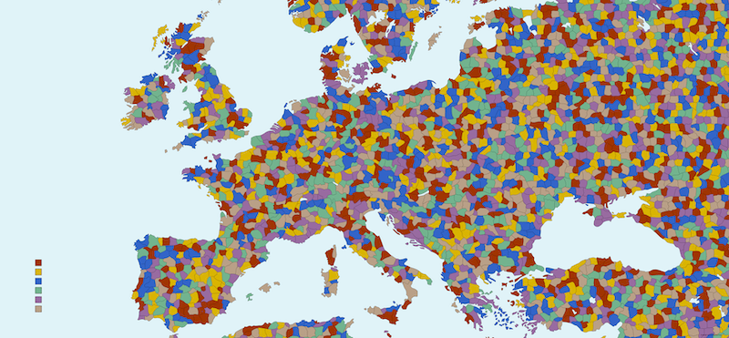
- A Victoria 3 Provinces map is now up and ready for you to dive into! This is by far the most detailed map on the site, with over 40,000 provinces. Notes:
- With so much detail, this map might slow down your device or even make your browser crash if it gets overwhelmed. So, take it slow and see how it goes.
- To improve performance, you can try:
- Zooming in and working on smaller sections at a time.
- Using a desktop with strong processing power and plenty of RAM.
- Closing any extra tabs to save resources.
- Switching off map borders to make it more responsive.
- The map is up-to-date with the latest version of the game (version 1.5).
- You can also display state borders on top of the map.
- If you're into crafting your own alternate history scenarios, this map is your new best friend. Give it a try, and let's see the worlds you create!
-
Here is a close-up on Europe in the new map ⬇️
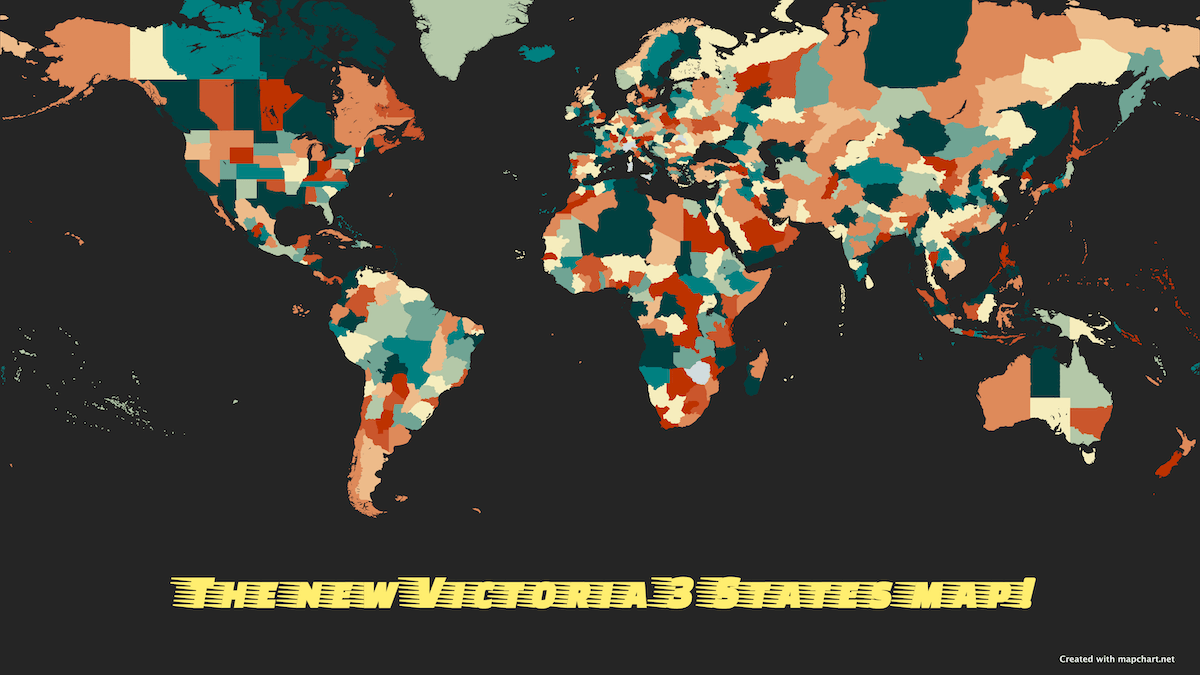
- A Victoria 3 States map is also available!
- The map is up-to-date with the latest version of the game (version 1.5).
-
Check it out! ⬇️
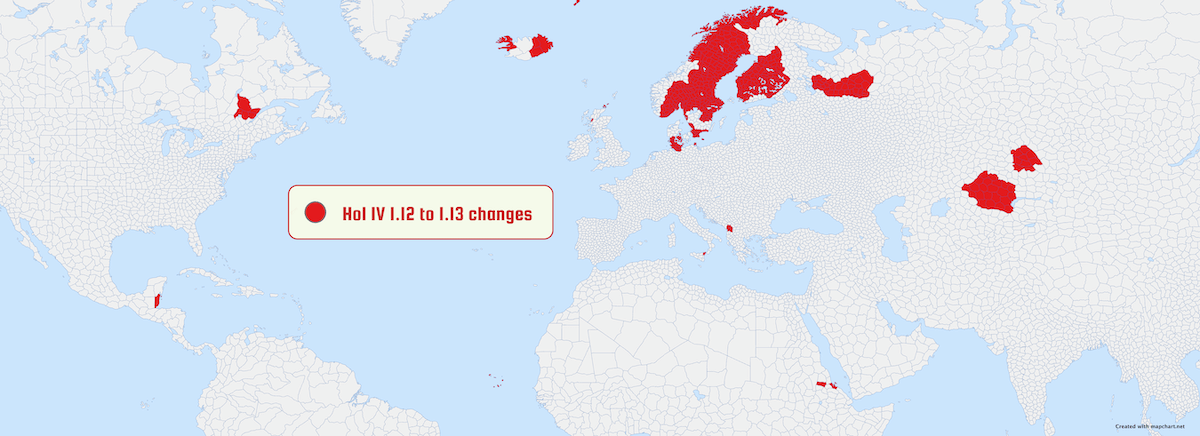
- The Hearts of Iron IV Provinces map has been updated to the latest version of the game (version 1.13, Arms Against Tyranny). Notes:
- Fixed all gaps between subdivisions!
- Added or changed borders in the Nordic countries: Jan Mayen, Jämtland, Västerbotten, Nordland, Norrbotten, Troms, Finnmark, Oulu, Lappi, Kuopio, Mikkeli, Häme, Turku, Kymi, Vaasa, Södermalm, Gävleborg, Uusimaa, Östergötland, Småland, Västergötland, Skåne, Dalarna, Värmland, Oslofjord, Opplandene, Telemark, Agder, Vestlandet, Trøndelag, Helgeland, Jylland, Sønderjylland, Fyn, Schleswig, Holstein, Sjaelland, Bornholm, Bohuslän.
- In the UK: split Northern England into Cumbria, Northumberland, and Isle of Man. Split Shetland_Islands from Scottish Highlands.
- In Albania: split into Albania and Shkodër.
- Fixed names of provinces in Maurice, Yukatan, Chukchi, Karagandy, Pavlodar, Eritrea.
-
Here is a map displaying all the changes ⬇️
- If you try to load a previously saved config file, some provinces may stay uncolored. You may need to recolor some provinces to get the same result as before.
- Finally, you can also display state borders on top of the map.
-
Legend updates and more customizations:
- You can now select a shape for the color boxes in the legend (square, circle, rectangle).
- You can now select a border color for the legend.
- It is now a lot more easier to resize the legend or change its width.
-
Check out a quick look at the new features ⬇️
-
A new free website theme is now available: Nord theme ❄️ .
- It's a sleek, dark theme inspired by the chilly vibes of winter.
-
Here it is in action ⬇️
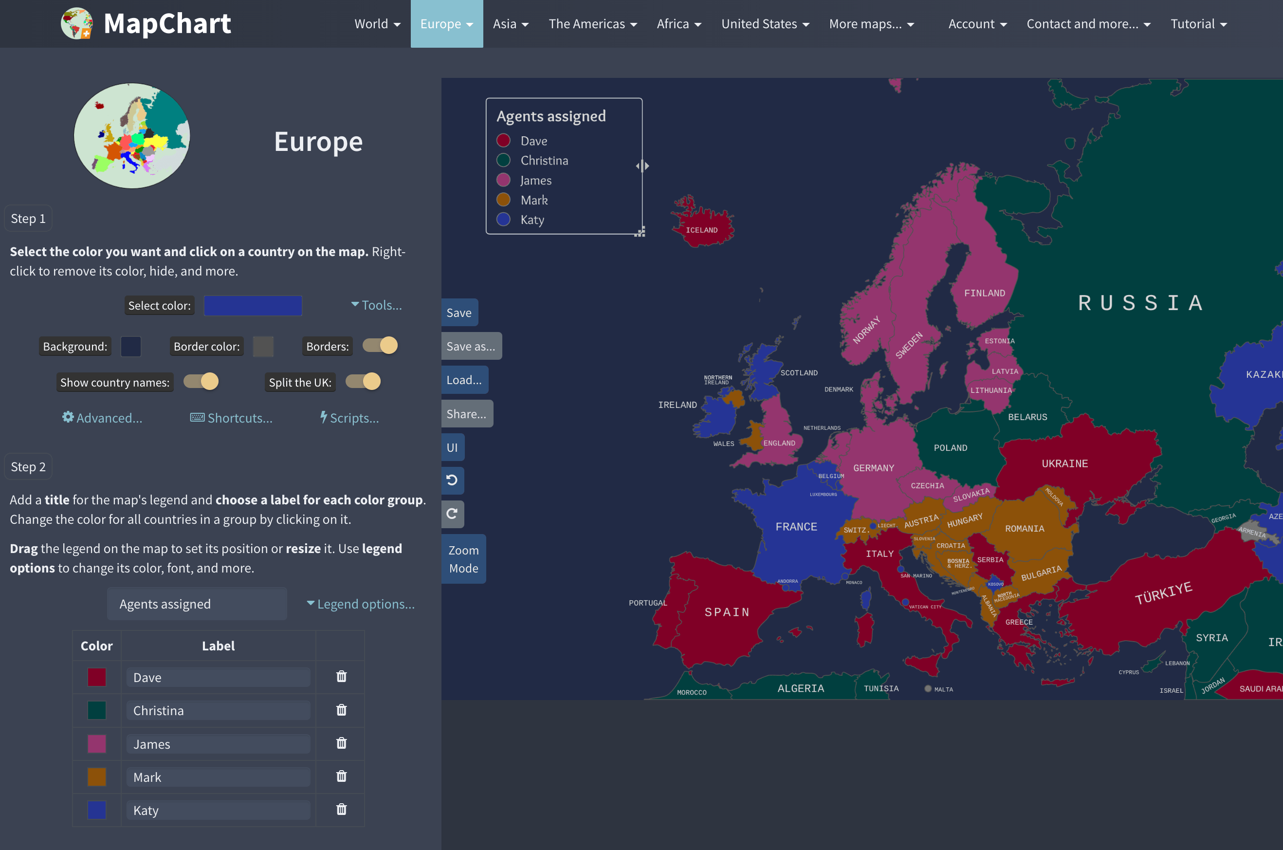
- You can select it from the UI menu next to the map, or just click here:
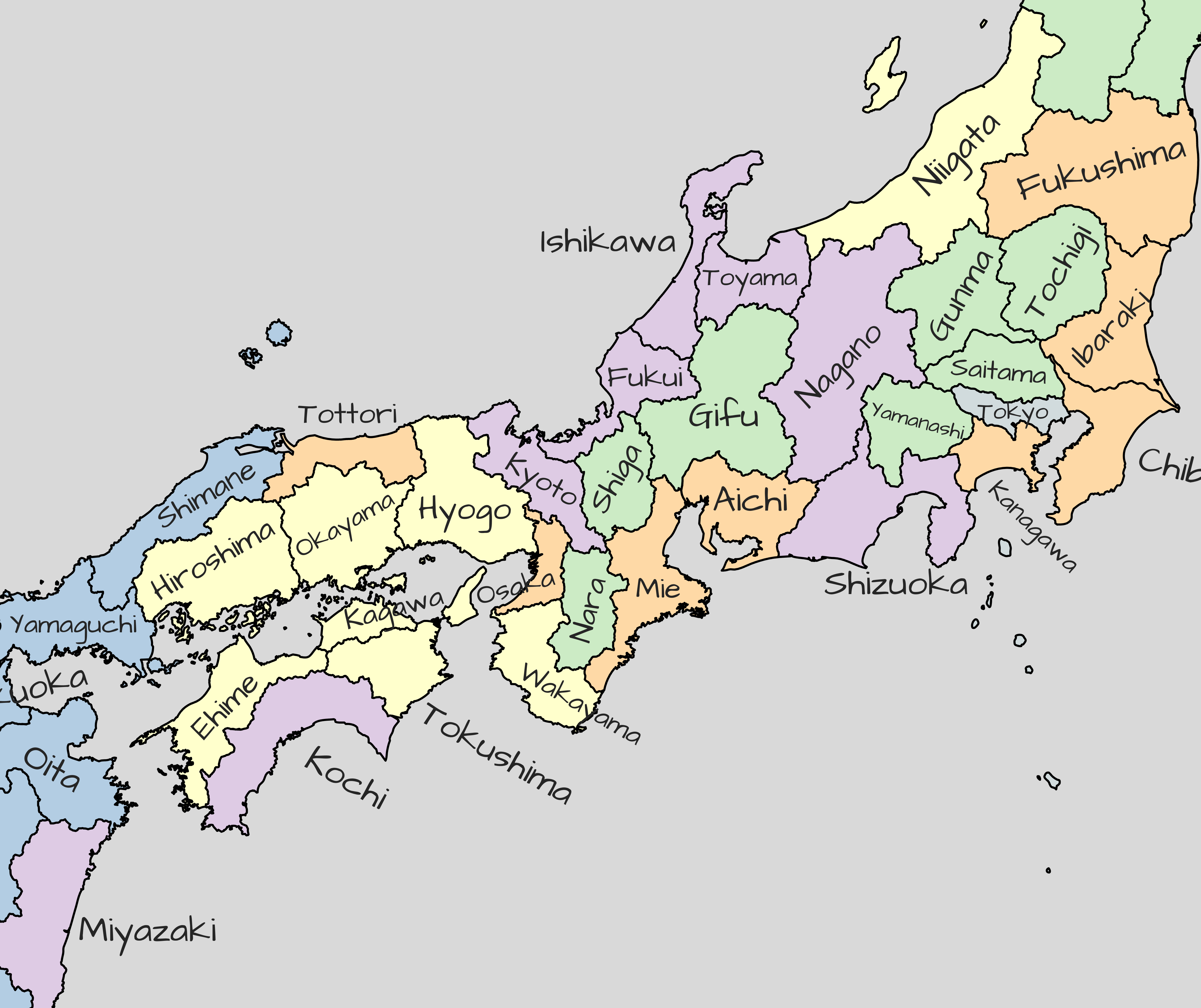
- You can now select a custom font for the country/state name labels.
- Find it in Step 1 > Advanced...
-
Here is using the Architect's Daughter font in a map of Japan ⬇️
- New shortcut: press B to quickly toggle borders on/off.
- Moving your mouse over a country/state, now displays the corresponding legend entry for it.
-
Check out the new behavior ⬇️
- This is now the default. Turn it off from Step 1 > Advanced....
-
- Using the website on mobile/tablet is a lot easier now. Cleaned up and reimplemented the interface. You can now see the tooltip at the bottom of the map. Also zooming should work more smoothly.
- If there is any update to the website, you will now see a pulsing red dot indicator in the navigation bar. After checking out the What's New page, it will go away.
- Fixed all gaps on all maps, including the Hearts of Iron IV States map, the World subdivisions map, and more.
- Europe/simple world map: improved the details of UK's constituent countries.
- Changing the background color will now change the color of some elements (like the sidemap outline) to a contrasting one.
- Saving and restoring map configurations, and using the Undo / Redo options, should now be a lot faster, especially for the larger maps. Also, the exported file size has been reduced for the larger maps.
- Slight redesign of the Save/Load Map Configuration dialog. You can now remove the file you just uploaded, check a preview of it, and more.
- Added French overseas regions to the EU and the Eurozone region grouppings (used in the world maps).
- Added more state splits for the US states map: you can now split Louisiana (N-S) and Idaho (N-S).
- Italy: fixed the borders between Rimini and Arezzo regions.
- World 1815: fixed an issue with Tuscany.
Version 4.3.5 - 15 December 2023
- The Birthday deal for Plus is now over. Thank you for your support!
Version 4.3.4 - 12 December 2023
- MapChart birthday deal: Get 40% off MapChart Plus!
- Celebrating 9 years of map-making excellence.
- The discount is valid for new subscriptions and all your future renewals!
- Offer will be available for the next few days.
Version 4.3.3 - 10 December 2023
- An issue affecting users with the uBlock Origin browser extension (or similar ad-blocking extensions) has been addressed.
- A recent uBlock Origin update mistakenly hid parts of the website, due to a newly added filter. This overly aggressive filter targeted and removed any content containing words that started with the substring "Adv," most notably impacting sections labeled "Advanced".
- As a workaround, the specific terms that triggered the block have been removed, and the extension's filter will be updated soon, after notifying its maintainers. The site should now work properly for everyone.
- Please refresh the site or clear your browser cache to see the changes. Contact me if you still have trouble.
Version 4.3.2 - 30 November 2023
- Fixed an issue with the HSL custom color picker.
- The Black Friday deal is now over. Thank you for your support!
Version 4.3.1 - 22 November 2023
- BLACK FRIDAY deal! Get 40% off MapChart Plus.
- The discount is valid for new subscriptions and all your future renewals!
- Offer will be available for the next few days.
Version 4.3.0 - 14 November 2023
- NEW! Color uncolored countries/states Script: Paint all the uncolored (still have the default color) countries with the color of your choice. A great way to save time and quickly color the remaining countries/states on your map.
- Fixed an issue where the Random Color scripts didn't work with the undo/redo functionality.
- Fixed an issue where, when picking a color from the map, the custom color input didn't update.
Version 4.2.6 - 8 November 2023
- Fixed an issue, where when having over 50 colors in the legend, the displayed warnings would not go away.
Version 4.2.5 - 5 November 2023
- US States map: fixed an issue, where hiding DE would display its north part in its place.
Version 4.2.4 - 4 November 2023
- Fixed an issue with some Scripts not working.
Version 4.2.3 - 3 November 2023
- US Congressional Districts map: updated (redrew) Alabama's districts, according to the recent Supreme Court ruling (Oct 5, 2023).
- World subdivisions/Europe detailed: added Guernsey.
- World subdivisions/Europe detailed: fixed names of Perthshire and Kinross > Perth and Kinross and Eilean Siar > Na hʼEileanan Siar in the United Kingdom.
- Argentina: fixed spelling of Famaillá and Ojo de Agua districts.
- Americas detailed map: fixed a minor issue with Ontario's borders.
- US States map: fixed an issue, where hiding MT, WY, CO, or NM would display their split parts instead.
- Fixed an issue where, when using the Random Color script, it would also color hidden countries/states on the map.
Version 4.2.2 - 14 October 2023
-
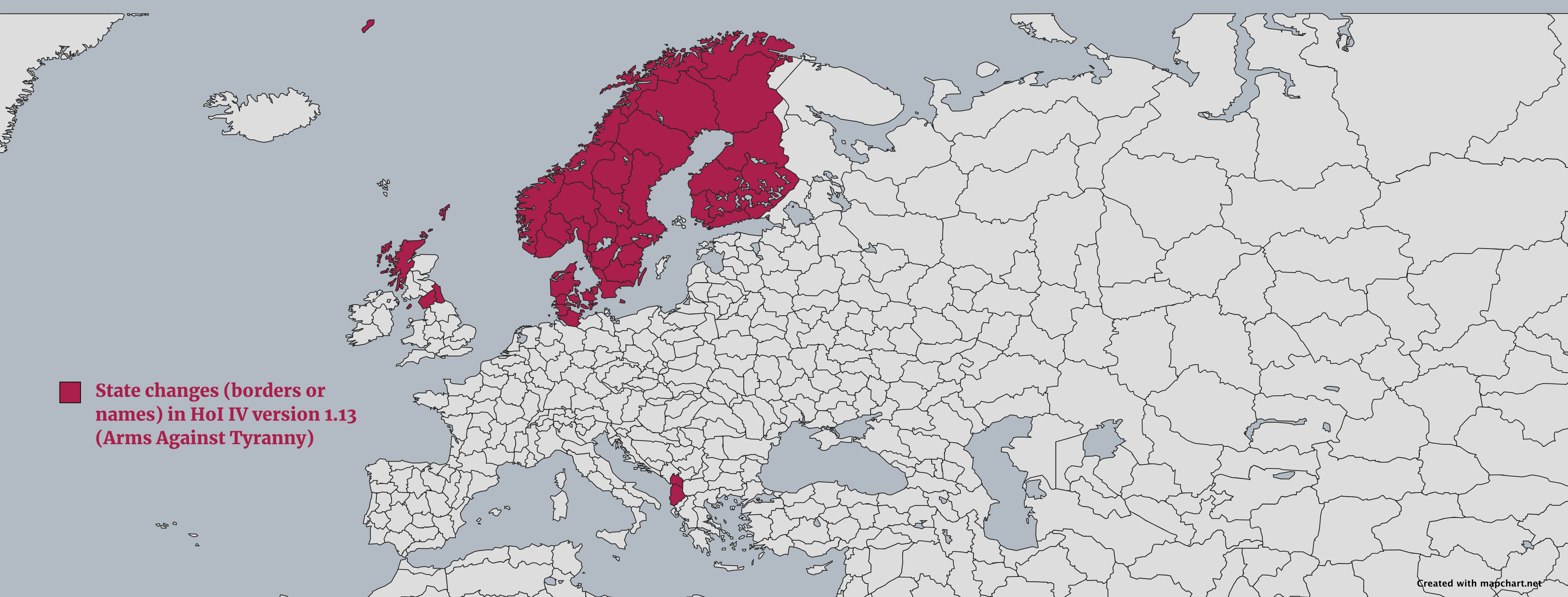
NEW! The Hearts of Iron IV states map has been updated for version 1.13 (Arms Against Tyranny) of the game. The changes are:
- Added or changed borders in the Nordic countries: Jan Mayen, Jämtland, Västerbotten, Nordland, Norrbotten, Troms, Finnmark, Oulu, Lappi, Kuopio, Mikkeli, Häme, Turku, Kymi, Vaasa, Södermalm, Gävleborg, Uusimaa, Östergötland, Småland, Västergötland, Skåne, Dalarna, Värmland, Oslofjord, Opplandene, Telemark, Agder, Vestlandet, Trøndelag, Helgeland, Jylland, Sønderjylland, Fyn, Schleswig, Holstein, Sjaelland, Bornholm, Bohuslän.
- In the UK: split Northern England into Cumbria, Northumberland, and Isle of Man. Split Shetland_Islands from Scottish Highlands.
- In Albania: split into Albania and Shkodër.
-
Here is a map displaying all the changes ⬇️
- Europa Universalis IV map: fixed the names and provinces of New Zealand's southern island (Timaru, Ata Whenua, and Te Tau Ihu).
- Hearts of Iron IV provinces: fixed capitalization of all Jiangxi provinces.
- UK historic counties: fixed an issue with the labels of Roscommon and Offaly.
Version 4.2.1 - 5 October 2023
- Fixed an issue with right-click > Do not scale patterns setting not working.
Version 4.2.0 - 1 October 2023
-
NEW! More Scripts! You can now use:
- Get map data as TSV: Extract the map's data (colors, labels, etc.) into an easy-to-import TSV format, suitable for Excel, Google Sheets, or similar. Just copy and paste it into your spreadsheet.
- Export map data as CSV: Extract the map's data (colors, labels, etc.) as a CSV file. Open it with Excel, Google Sheets, or similar.
-
Check an example of getting the map's data in TSV format and pasting it into Excel: ⬇️
- Find them in Step 1 > Scripts....
- Also fixed an issue where using a script more than once would not produce output.
Version 4.1.1 - 27 September 2023
- Advanced world map/US Congressional Districts: fixed an issue where, when changing projection or Congress version, the map would not download on mobile iOS browsers.
- Asia/Europa Universalis IV: renamed East Timor to Timor Leste 🇹🇱 for consistency purposes.
- World subdivisions: fixed gaps between Azerbaijan and Iran provinces.
Version 4.1.0 - 24 September 2023
- You can now pick a color from the map when selecting:
- A new color for the current legend entries.
- Background color.
- Border color.
- Legend font color.
- Legend background color.
- New keyboard shortcut! Press F
to pay respectsto quickly pick a color from the map. -
Check the new features: ⬇️
Version 4.0.8 - 18 September 2023
- Added a link to MapGame at the bottom of each page, for quick access.
- Added more state splits for the US states map: you can now split Montana (N-S), Wyoming (N-S), Colorado (N-S), and New Mexico (N-S).
- World subdivisions: fixed name of Al Manāmah in Bahrain 🇧🇭.
- Europa Universalis IV: fixed name of Yapeyú province.
Version 4.0.7 - 13 September 2023
- Fixed an issue where coloring multiple subdivision groups (e.g. states in the US counties map) would not handle diplaying state labels and borders properly, if the states were already isolated.
Version 4.0.6 - 8 September 2023
- Added more state splits for the US states map: you can now split North Dakota (W-E), South Dakota (W-E), Nebraska (W-E), Kansas (W-E), and Virginia (N-S).
- Fixed an issue where the selection tools wouldn't work properly on the Americas and India maps.
- Fixed an issue where coloring multiple subdivision groups (e.g. states in the US counties map) would not work properly with the undo/redo mechanism.
Version 4.0.5 - 7 September 2023
- Fixed an issue where loading map configurations that included isolated subdivision groups (e.g. states in the US counties map) would not display the saved data properly on the map.
Version 4.0.4 - 4 September 2023
- World subdivisions/Africa detailed: added Rumonge province to Burundi 🇧🇮.
- World subdivisions/Africa detailed: fixed borders between provinces of South Africa 🇿🇦. Also fixed name of Free State province.
- World subdivisions/Europe detailed: now displaying IJsselmeer inland bay in Netherlands 🇳🇱 properly.
- The Caribbean: added Sint Eustatius and Saba to the map.
- World (simple): Liechtenstein 🇱🇮 is now displayed with a circular shape for easier coloring. Also added its name label.
- Europa Universalis IV: fixed name errors. Sain Noyon is now Qaraqorum and former Qaraqorum is now Bayankhongor.
Version 4.0.0 - 1 September 2023
M
A
P
G
A
M
E
L
A
U
N
C
H
E
D
!
Version 3.15.3 - 16 August 2023
- Europe detailed: fixed an issue where loading a config would not color some of North Macedonia's municipalities.
- Europe detailed: Vatican City is now displayed on the map.
- Asia: Phú Quốc island is now properly displayed as part of Vietnam.
- World advanced/US Congr. Districts: fixed an issue where, when changing map projection or the selected congress map, the Zoom button would disappear.
- Fixed an issue where, on maps with multiple subdivision levels, showing and then making transparent a hidden subdivision would glitch.
Version 3.15.2 - 13 August 2023
- World subdivisions/Europe detailed: added Zeta municipality to Montenegro 🇲🇪.
- Fixed an issue in the Pacific-centered world map where the selection tools (rectangle, ellipse, etc.) didn't select properly.
- Fixed an issue where restoring the isolated states in the US Counties and Congr. Districts maps would not enable back some of the switches in Step 1.
- Fixed an issue where the area around Great Yarmouth was not shown in the UK 🇬🇧 counties map.
- Fixed typo in the Hearts of Iron IV Provinces map (Northern Territory 01).
Version 3.15.1 - 2 August 2023
- World with microstates map:
- Qatar 🇶🇦 and Eswatini 🇸🇿 are not displayed as a circle any more, but with their real outline.
- Fixed border between Serbia 🇷🇸 and Montenegro 🇲🇪, and Egypt 🇪🇬 and Sudan 🇸🇩.
- Added Estonia's 🇪🇪 islands to the map.
- Africa map: fixed border between Egypt 🇪🇬 and Sudan 🇸🇩.
- World subdivisions/Asia detailed: renamed Province No.1 to Koshi in Nepal 🇳🇵.
- World subdivisions: restoring older map configurations should now restore North Macedonia's 🇲🇰 provinces properly.
Version 3.15.0 - 1 August 2023
- NEW! Do you also use Google Sheets? Check out the brand new MapChart for Google Sheets add-on, that lets you create a custom map from your Google Sheets data!
- Relevant blog post.
Version 3.14.5 - 28 July 2023
- Fixed issues with the Excel to MapChart Configuration Export tools (for Windows and macOS):
- Renamed Shannon_SD to Oglala_Lakota_SD.
- Fixed spelling of Mc Kinley_NM and Orange_FL.
- Added Chugach_AK and removed Valdez-Cordova_AK.
Version 3.14.4 - 28 July 2023
- World subdivisions/Europe detailed: fixed an issue with Lake Ladoga not being displayed.
- World subdivisions/Africa detailed: renamed Orissa_IN to Odisha_IN, and Uttaranchal_IN to Uttarakhand_IN.
- Portugal 🇵🇹: fixed borders between Braga and Porto provinces (Vizela municipality).
- Netherlands 🇳🇱: fixed borders between Gelderland and Overijssel provinces (Hattem municipality).
- World subdivisions: fixed an issue with Latvian subdivision border width.
Version 3.14.3 - 23 July 2023
-
NEW! Europe detailed: remade the whole map to be displayed in the Robinson projection, similarly to the other detailed maps. This came with a lot of fixes and improvements:
- Fixed all gaps between borders.
- Added Apace_SI, Azores_PT, Madeira_PT, Blackpool_UK, Ceuta_ES, Melilla_ES, Šmartno_in_Litiji_SI, Struga_MK, Šuto_Orizari_MK, Svalbard_NO.
- Removed Sark_OT and UN_buffer_zone_OT.
- Dublin is now split into South-Dublin_IE, Fingal_IE, Dún-Laoghaire–Rathdown_IE.
- Name fixes: Bourgogne_FR > Bourgogne-Franche-Comté_FR, Eastern_MK > Zrnovci_MK, Gorenjska_SI > Radovljica_SI, Jugovzhodna_Slovenija_SI > Dolenjske_Toplice_SI, Koroška_SI > Slovenj_Gradec_SI, Lódz_PL > Łódź_PL, Noròurland_Vestra_IS > Norðurland_vestra_IS, Northeastern_MK > Staro_Nagoricane_MK , Notranjsko-kraška_SI > Pivka_SI , Osrednjeslovenska_SI > Ljubljana_SI, Päijänne_Tavastia_FI > Päijät_Häme_FI, Pelagonia_MK > Mogila_MK, Phecevo_MK > Pehcevo_MK, Podravska_SI > Starše_SI, Polog_MK > Vrapcište_MK, Pomurska_SI > Murska_Sobota_SI, Savinjska_SI > Žalec_SI, Southeastern_MK > Strumitsa_MK, Southwestern_MK > Plasnica_MK, Spodnjeposavska_SI > Krško_SI, Swietokrzyskie_PL > Świętokrzyskie_PL, Vardar_MK > Rosoman_MK.
- World subdivisions: the detailed Europe map update resulted in a lot of fixes on this map too:
- Merged Liechtenstein's subdivisions into one.
- All the additions, removals, name fixes from the Europe update, and additionally: Středoceský_CZ > Stredoceský_CZ, Kriti_GR > Crete_GR, Dytiki_Makedonia_GR > Western_Macedonia_GR, Voreio_Aigaio_GR > North_Aegean_GR, Anatoliki_Makedonia_kai_Thraki_GR > Eastern_Macedonia_and_Thrace_GR, Dytiki_Ellada_GR > Western_Greece_GR, Kentriki_Makedonia_GR > Central_Macedonia_GR, Notio_Aigaio_GR > South_Aegean_GR, Corse_FR > Corsica_FR, Baden-W__rttemberg_DE > Baden-Württemberg_DE, Eysturoyar_FO > Eysturoyar_DK, Aug__daugavas_novads_LV > Augšdaugavas_novads_LV, R__zeknes_novads_LV > Rēzeknes_novads_LV, Noròurland_Vestra_IS > Norðurland_vestra_IS, Chişinău_MD > Chișinău_MD, Floreşti_MD > Florești_MD, Świetokrzyskie_PL > Świętokrzyskie_PL, Lódź_PL > Łódź_PL, Južno_Banatski_RS > Južno-Banatski_RS, Ju__no-Backi_RS > Južno-Backi_RS, North_Tiperrary_IE > Tiperrary_IE.
- For 99% of cases, loading a previously saved map should automatically take into account all these name fixes. However, please note that you may find some subdivisions uncolored, so you will need to recolor them manually.
- Fixed an issue with the cursor not being updated when using Ctrl + hold shortcuts.
- Romania 🇷🇴: fixed name of Ariceștii_Rahtivani_PH.
- World subdivisions/Africa detailed: added South West Ethiopia Peoples province to Ethiopia 🇪🇹.
- World subdivisions/Africa detailed: added Chobe and Ngamiland districts to Botswana 🇧🇼.
- US counties: fixed borders between Prince Wales-Hyder and Petersburg census areas in Alaska.
Version 3.14.2 - 8 July 2023
- Africa detailed: fixed all gaps between subdivision borders.
- World subdivisions/Africa detailed: added North Western province in Sierra Leone 🇸🇱.
- World subdivisions/Africa detailed: fixed borders of Dubréka and Conakry in Guinea 🇬🇳.
- World subdivisions/Africa detailed: fixed borders of Bengui and Ombella M' Poko in Central African Republic 🇨🇫.
- World subdivisions/Africa detailed: fixed borders of counties in Croatia 🇭🇷.
- Americas detailed: fixed an issue with the Great Lakes not being displayed on the map.
- World subdivisions/Asia detailed: fixed name of Al_Manāmah_BH in Bahrain 🇧🇭.
- Japan 🇯🇵: fixed names of Kochi and Oita prefectures.
- Fixed an issue where uploading a configuration with a custom legend position would sometimes place the legend out of bounds.
Version 3.14.1 - 4 July 2023
- Americas detailed map: fixed all gaps between subdivision borders. Also, minor updates to some subdivision names.
- US states map: fixed placement of DC.
Version 3.14.0 - 3 July 2023
-
NEW! [Plus] When you load a saved map, you can now also load a configuration from a compatible map page, for example:
- Transfer a design from the advanced world map to the simple world map.
- Apply a Europe, Africa, Asia, or The Americas map to a world map and vice versa (non-applicable territories will be ignored).
- Load a US states map on the US & Canada map.
- This feature can be handy when you want to transfer or expand your map data between different maps.
- To find compatible saved maps, in the Load dialog, select Compatible maps at the top right. Select the one you want and hit Load.
-
See how it works (loading a US states map on the US & Canada map): ⬇️
Version 3.13.2 - 2 July 2023
- World subdivisions/Asia detailed: updated borders of Ar Riyad, Ash Sharqiyah, Najran, Al Jawf, Al Hudud ash Shamaliyah, Tabuk, Ha 'il, Ar Quassim in Saudi Arabia 🇸🇦.
- World subdivisions/Africa detailed: updated borders of Bengo and Luanda in Angola 🇦🇴.
- World subdivisions/Africa detailed: added Orapa town district to Botswana 🇧🇼.
- Americas detailed: added Islas de la Bahia province to Honduras 🇭🇳.
- Africa detailed: fixed some border gaps between subdivisions.
Version 3.13.1 - 1 June 2023
- Converted all names of municipalities in the Mexico 🇲🇽 map to display their state's ISO code instead (e.g. San_Dimas_MX10026 -> San_Dimas_DUR).
- Fixed an issue with the name labels for maps that have multiple subdivision layers (e.g. Mexico, Ukraine, Italy, etc.).
- Fixed an issue where the right-click menu and submenus were overflowing the available space. This was most prominent with the US states map Split States option.
Version 3.13.0 - 30 May 2023
- NEW! The Mexico 🇲🇽 map has been updated to show all 2,547 Mexican municipalities!
- You can also display the 32 Mexican states as a separate layer, on top of the municipalities. Use the options in Step 1 to set the visibility/transparency of states.
- Added more state splits for the US states map: you can now split Michigan (N-S), Maine (N-S), South Carolina (W-E), Montana (W-C-E), Wyoming (W-E), and Colorado (W-E).
- Optimized switching layers on maps that have multiple subdivision layers (e.g. Mexico, Ukraine, Italy, etc.).
- Fixed an issue where loading a saved US states map displayed some duplicate state labels.
Version 3.12.1 - 29 May 2023
- Fixed an issue where, when you had the Ellipse (E), Rectangle (R) or Polygon (P) tool selected, dragging the legend around would also start a selection.
- Improved how the legend labels are split into lines. If you enter a long label without spaces, it now behaves properly.
- World with microstates: fixed the label of Chile not showing up.
- Netherlands: fixed the borders between North and South Holland (municipality of Hillegom).
Version 3.12.0 - 26 May 2023
-
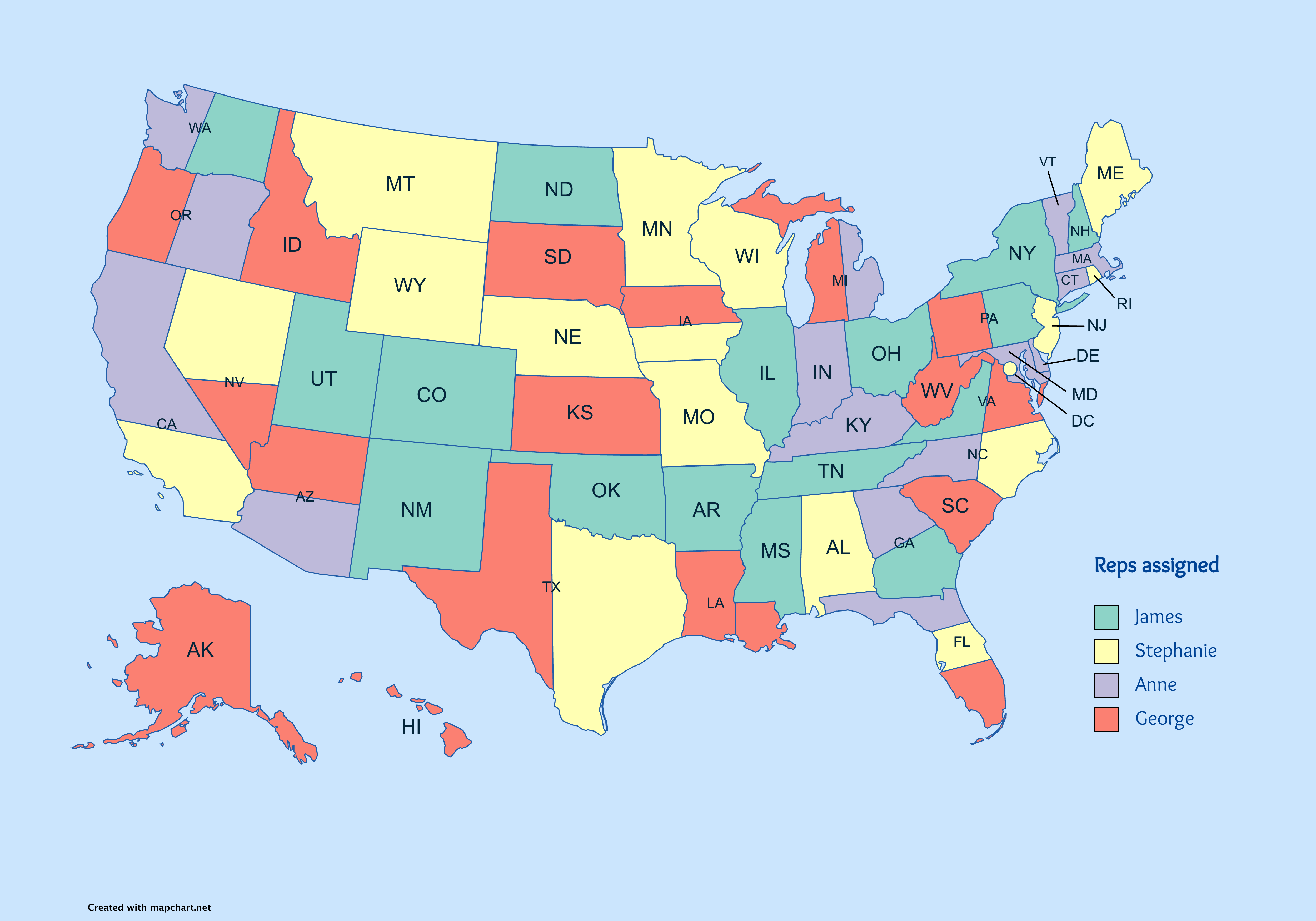
NEW! You can now split a state into parts in the US states map:
- Right-click on a state and select Split state into parts .
- Examples include splitting California into Northern/Southern, splitting Pennsylvania into Eastern/Western, etc.
- To go back, right-click on a state part and select Show state as a whole or use the Undo button.
- ⚠️ Not all states can be split. For suggestions, let me know through the Feedback page.
- The way each state is split is mostly arbitrary and meant to be used as a way to further customize your map.
- This is only available for the US states map page.
- States that can be split: AL, AR, AZ, CA, DE, FL, GA, IA, IL, IN, KY, LA, MD, MI, MO, MS, NC, NJ, NV, NY, OH, OK, OR, PA, TN, TX, UT, VA, WA, WI, WV.
-
See an example map with split states: ⬇️
Version 3.11.2 - 23 May 2023
- World subdivisions: added Halabja province to Iraq 🇮🇶.
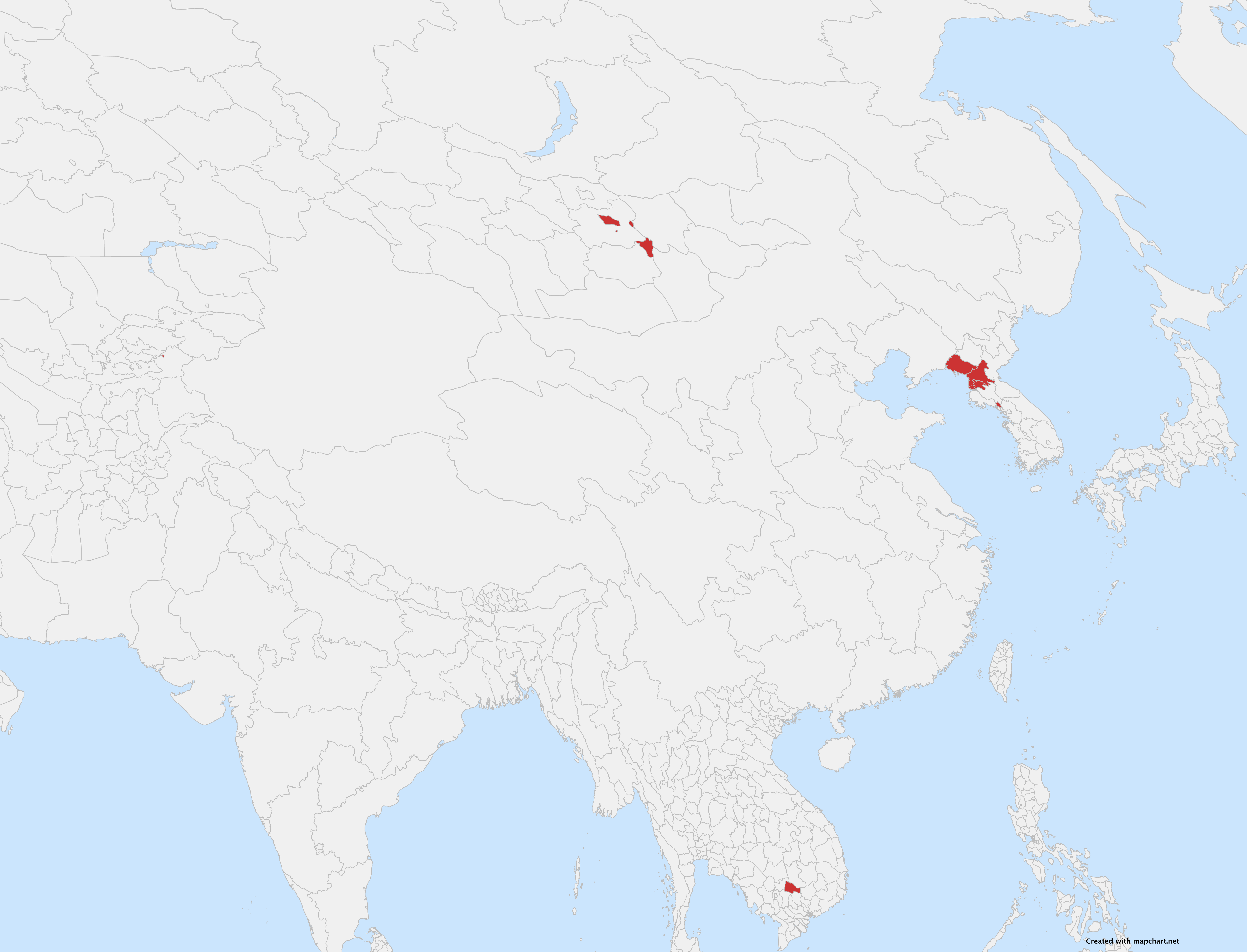
- World subdivisions/Asia detailed:
- Updated Ulaanbaatar's borders in Mongolia 🇲🇳 and added Govisumber province.
- Added Osh City to Kyrgyzstan's 🇰🇬 subdivisions.
- Added Tboung Khmum province to Cambodia 🇰🇭.
- Fixed Pyongyang provinces' name issues in North Korea 🇰🇵.
- Added Nampo City and Kaesong City to North Korea's 🇰🇵 subdivisions.
-
See the changes on the map: ⬇️
Version 3.11.1 - 22 May 2023
- NEW! On the Türkiye 🇹🇷 map, you can now display the 7 geographical regions as a separate layer, on top of the provinces. Use the options in Step 1 to set the visibility/transparency of geographical regions.
Version 3.11.0 - 21 May 2023
-
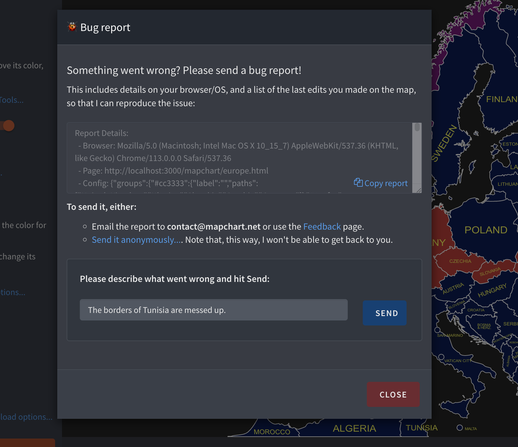
NEW Added a Report a bug... option on all map pages:
- Clicking it will open a dialog where you will find a complete report, including info on your browser, your map settings, and your latest actions.
- You can copy the report and send it via e-mail (or the Feedback page), or just submit it anonymously.
- It is the easiest way for me to reproduce and work on the issue you are facing.
- You will find the Report a bug... in Step 3 of all map pages.
-
See it in action: ⬇️
- Fixed some issues with how changing subdivision levels works on maps with multiple subdivision levels (e.g. Ukraine, Belgium, Spain, etc.).
- Changing subdivision levels on these maps is now available in the undo/redo functionality.
Version 3.10.11 - 15 May 2023
- [Plus] Added info on the Plus subscription price in the Account Settings page.
- [Plus] Added info on what happens when a Plus subscription expires.
- Fixed an issue with the cursor when coloring the map using the Rectangle, Ellipse, or Polygon tools.
Version 3.10.10 - 14 May 2023
- [Plus] Added or made easier to use some account-related actions, directly from the Account Settings page, including:
- Getting your receipt/invoice for your Plus purchase.
- Updating your payment method (via Gumroad).
- Cancelling/restarting your subscription (with steps on how to do so via Gumroad).
- You will also now know if, when cancelling, you are eligible for a refund.
- The FAQ has been updated to reflect these changes and clear up subscription-related documentation.
- Fixed an issue where, when changing group color from the legend boxes and then deleting the group altogether, would afterwards cause issues with coloring new elements.
- World subdivisions/Asia detailed: fixed islands between Kagoshima and Okinawa in Japan 🇯🇵.
- Germany 🇩🇪: fixed border between the districts of Hessen and Rheinland-Pfalz.
- Belgium 🇧🇪: fixed border between Limburg and Liege.
- Belgium 🇧🇪: renamed Bitsingen to Bassenge.
- Poland 🇵🇱: fixed name of Opole City.
Version 3.10.9 - 28 April 2023
- NEW! On the Belgium 🇧🇪 map, you can now display the 11 provinces as a separate layer, on top of the municipalities. Use the options in Step 1 to set the visibility/transparency of provinces.
- Added Greenland 🇬🇱 to the Americas 🌎 map.
Version 3.10.8 - 27 April 2023
-
NEW! Easier-to-read legends with adjustable width:
- Make your legend wider if the text is too long and hard to read.
- Text will automatically fit within the adjusted width, making it neater and easier to understand.
- To change the width, just drag the handle at the edge of the legend.
-
See it in action: ⬇️
- Fixed an issue where restoring map configurations with isolated groups (e.g. restoring isolated California on the US Counties map) didn't work.
- Advanced World/US Congressional Districts/US Electoral College Cartogram: fixed an issue where changing the map didn't set the new map's dimensions correctly, when downloading the final image.
- World 1938: fixed name of Vatican City.
- Small UI improvements.
Version 3.10.7 - 21 April 2023
- NEW! On the Spain 🇪🇸 map, you can now display the 19 autonomous communities as a separate layer, on top of the provinces. Use the options in Step 1 to set the visibility/transparency of autonomous communities.
- NEW! On the Netherlands 🇳🇱 map, you can now display the 12 provinces as a separate layer, on top of the municipalities. Use the options in Step 1 to set the visibility/transparency of provinces.
- Fixed an issue where the historical US map slider would not work.
- Restored some missing icons in menus and buttons.
Version 3.10.6 - 20 April 2023
- NEW! On the Germany 🇩🇪 map, you can now display the 16 states (Länder) as a separate layer, on top of the districts (Landkreise/Stadtkreise). Use the options in Step 1 to set the visibility/transparency of states.
- The previously separate German states and districts map pages have now been merged to the updated Germany map page.
- NEW! On the Portugal 🇵🇹 map, you can now display the 20 districts as a separate layer, on top of the municipalities. Use the options in Step 1 to set the visibility/transparency of districts.
- Improved switching the visibility/transparency of additional layers and how borders/labels behave.
- World subdivisions: added Shymkent City to Kazakhstan's 🇰🇿 subdivisions.
Version 3.10.5 - 18 April 2023
- Fixed a bug 🐛 causing major performance issues on maps with a lot of elements.
- Fixed an issue with the Hears of Iron IV provinces map, where the color by state feature was broken.
Version 3.10.4 - 18 April 2023
- NEW! On the Italy 🇮🇹 map, you can now display the 20 regions as a separate layer, on top of the provinces. Use the options in Step 1 to set the visibility/transparency of regions.
- Replaced the switches for changing the visibility/transparency of additional layers in the Romania 🇷🇴 and Ukraine 🇺🇦 map with dropdowns.
- Fixed an issue with the color multiple countries/states feature, where you were not able to paste comma-separated abbreviations.
- Fixed an issue with the updated color/isolate multiple countries/states features not working in the EU NUTS 2/3 and Oceania detailed maps.
- World subdivisions/Asia detailed: added Papua Barat Daya to Indonesian 🇮🇩 provinces.
- World subdivisions/Asia detailed: renamed 11 of Indonesia's 🇮🇩 provinces to their Indonesian name (e.g. renamed Central Papua to Papua Tengah).
- Asia detailed: added Shymkent City to Kazakhstan's 🇰🇿 subdivisions.
- Fixed minor bugs here and there.
Version 3.10.3 - 13 April 2023
- Fixed an issue with the War Games map special features.
Version 3.10.2 - 13 April 2023
-
NEW! When using the isolate or color multiple countries/states feature, you can now:
- Search for the available ones and add them (instead of adding them manually).
- Include regions/organizations in your selection. For example, you can choose to isolate all countries in Southern Asia, Japan, and Mongolia (without having to add them all one-by-one).
-
See it in action: ⬇️


Version 3.10.1 - 10 April 2023
- Hearts of Iron IV states map:
- Merged Shetland into Scottish Highlands.
- Added the following states: Karagandy, Pavlodar, Kargopol, Kotlas, and Chukchi Peninsula.
- Fixed the names of Elisabethville, Khakassia, Lazio, Lombardia, North Transylvania, Piemonte, Sardegna, Sicilia, Toscana, Vorarlberg, and Zambesi.
- Hearts of Iron IV provinces map: added Saint Pierre and Miquelon (was previously part of Newfoundland).
- Türkiye: display Imrali island as part of Bursa province, not Yalova.
Version 3.10.0 - 9 April 2023
- NEW! Rectangle, ellipse, and polygon selection tools!
- Now you can easily select and color multiple countries or states at the same time, making your map coloring experience even better:
- Next to the Select color color picker, you will find a Tools... dropdown.
- Click it and choose the tool you want: Single-click, Rectangle, Ellipse, or Polygon.
- Draw your selection on the map.
- All countries/states you select will be immediately colored with the selected color.
- You can also configure the selection behavior.
- Use shortcuts for switching between the different selection modes:
- S for Single-click selection.
- R for the Rectangle tool.
- E for the Ellipse tool
- P for the Polygon tool.
-
See it in action: ⬇️
Version 3.9.6 - 4 April 2023
- Added Finland 🇫🇮 to NATO countries in the Region selection feature of the world maps.
Version 3.9.5 - 30 March 2023
- Fixed an issue where the map would download as a blank image on the latest Safari version (v16.4).
Version 3.9.4 - 30 March 2023
- US hex cartogram: Fixed issues with the color of the borders.
Version 3.9.3 - 30 March 2023
- World subdivisions/Asia detailed: Renamed South_Kazakhstan_KZ to Turkistan_KZ 🇰🇿.
- Fixed issues with the appearance of buttons.
Version 3.9.2 - 21 March 2023
- World subdivisions/Asia detailed: Renamed Nursultan_KZ to Astana_KZ 🇰🇿.
- Asia detailed: fixed name of Thừa_Thiên_-_Huế_VN.
- Ukraine: renamed Novohrad_Volynska_UA1808015 to Zviahel_UA_1808015 and Novohrad_Volynskyi_UA1808 to Zviahel_UA1808.
Version 3.9.1 - 17 March 2023
- All exported maps in PNG or JPEG format, have a DPI of 300 now. This can be helpful for printing large images or when viewing them on high resolution screens.
- World subdivisions/Asia detailed: Added the newly created Abai, Ulytau, and Jetisu regions to Kazakhstan 🇰🇿.
- Asia detailed: added lake outlines to the map.
Version 3.9.0 - 15 March 2023
-
NEW!
Speak and you shall be heard! After popular demand, the Preview Map button has been brought back to the Step 3 of the map creation process. You can now:
- Choose the behavior you want for the download process: either directly Download your map or Preview it and then download it (the previous process). Your preference will also be saved locally for all your MapChart visits.
- If you Preview your map, you can now also use the Copy button to copy the image to your clipboard. (not available on Firefox for now).
- In both cases, you are able to get your map in PNG, JPEG, or SVG formats and set the dimensions (width/height) you want.
-
Check the reinstated features ⬇️
- Various UI improvements, especially for the Simple and Simple - Reversed UI layouts.
Version 3.8.1 - 12 March 2023
- Fixed an issue with changing projection or map versions on the World Advanced, US Congressional Districts, and US hex cartogram pages.
Version 3.8.0 - 9 March 2023
-
NEW! The download process has been revamped:
- It is now possible to specify the width and height of the downloaded image, with a range of values starting from 500px and going up to 10,000px.
- You can now download your map as a JPEG, instead of PNG format.
- You can now download your map as an SVG (vector image) too!
- There is no Preview Map step any more. Instead, you can directly click on Download Map to obtain the map as an image.
-
Find the new settings in Step 3 > Download options... ⬇️
- World subdivisions/Europe detailed: fixed and improved the borders of Cyprus' subdvisions.
- World subdivisions: fixed an issue with Anguilla.
- Added Greenland and removed French Guiana to/from NATO in the Region Selection feature of the world maps.
- Renamed the Changelog page (this page) to What's New.
- Various improvements to the user interface.
Version 3.7.6 - 2 March 2023
- If you are on ChromeOS (i.e. Chromebooks), some shortcuts have been changed to avoid conflicts with system shortcuts. You should now:
- Hold Alt (and not Ctrl) and move over the map to paint countries/provinces (you can customize this).
- Hold Alt (and not Ctrl) and Shift, and move over the map to perform the opposite action.
- Hold Ctrl-Shift (and not Alt-Shift) and click on a country/province to paint the whole state/region.
Version 3.7.5 - 6 February 2023
- NEW! When you isolate a country or state in maps like the US Counties or World subdivisions, this is now saved in your map configurations. So, if you later resume your map, you will be shown the isolated map, exactly as you saved it.
-
Example (for a Plus user, but it's the same if you use the text files) ⬇️
- Fixed the map displayed in the World - 1815 map logo.
Version 3.7.4 - 4 February 2023
- Rearranged the menu at the top navigation bar: you can now find all non-map pages and links under the Contact and more... submenu.
- The previously named Feedback page is now two separate pages: a Contact and an About page. Their content has also been updated.
- The COVID-19 daily statistics map page is now archived. This means that it won't be updated any more with new data. You can still use it to check out COVID-19 related data from August 6th, 2020 and up to January 31st, 2023.
Version 3.7.3 - 26 January 2023
- NEW! Do you also use Airtable? Check out the brand new MapChart for Airtable extension, that lets you visualize your base's records on a map!
- World with microstates: Fixed label of Chile not showing up.
Version 3.7.2 - 22 January 2023
- Africa detailed/World subdivisions maps: Added Djibloho province to Equatorial Guinea 🇬🇶.
- Fixed an issue where the color of state borders wouldn't change in the US counties and US Congressional Districts maps.
Version 3.7.1 - 18 January 2023
- World subdivisions/Americas detailed maps: fixed names of Guyana's regions 🇬🇾.
- Europa Universalis IV map:
- Added Weagamow to the wastelands list.
- Cree is now part of the Iyiyiw province.
- Cayman Islands is now part of the Moron province.
- Fixed an issue where picking a color from the map ( Pick from map) didn't work properly.
Version 3.7.0 - 16 January 2023
- NEW! Added new keyboard shortcuts for many frequent map-making actions, including Z to enter Zoom Mode, C to quickly open the color picker, and Control + S to save your progress.
- Check the full list in the Step 1 > Shortcuts dialog, or the image below.
-
Check out the list of all available keyboard shortcuts ⬇️
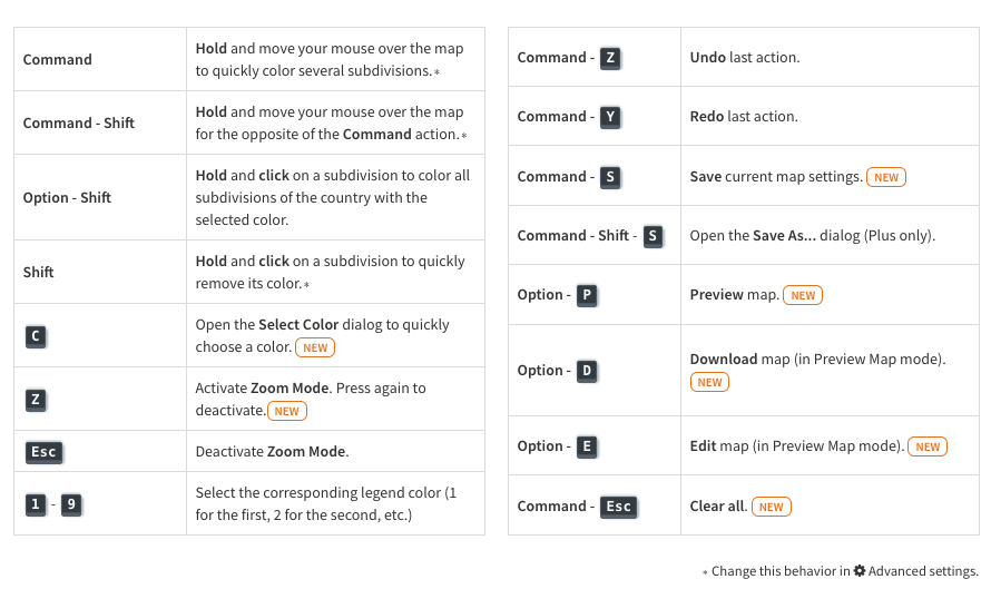
- Fixed an issue where if you attempted to color en masse hidden countries/states, it wouldn't work as intended.
- Coloring en masse (Ctrl + move) should be a bit snappier now.
Version 3.6.3 - 13 January 2023
- When you isolate multiple states on the US counties and US Congressional Districts maps, you can now properly display the isolated states' borders and abbreviations.
-
Before/after example of an isolated states' map ⬇️
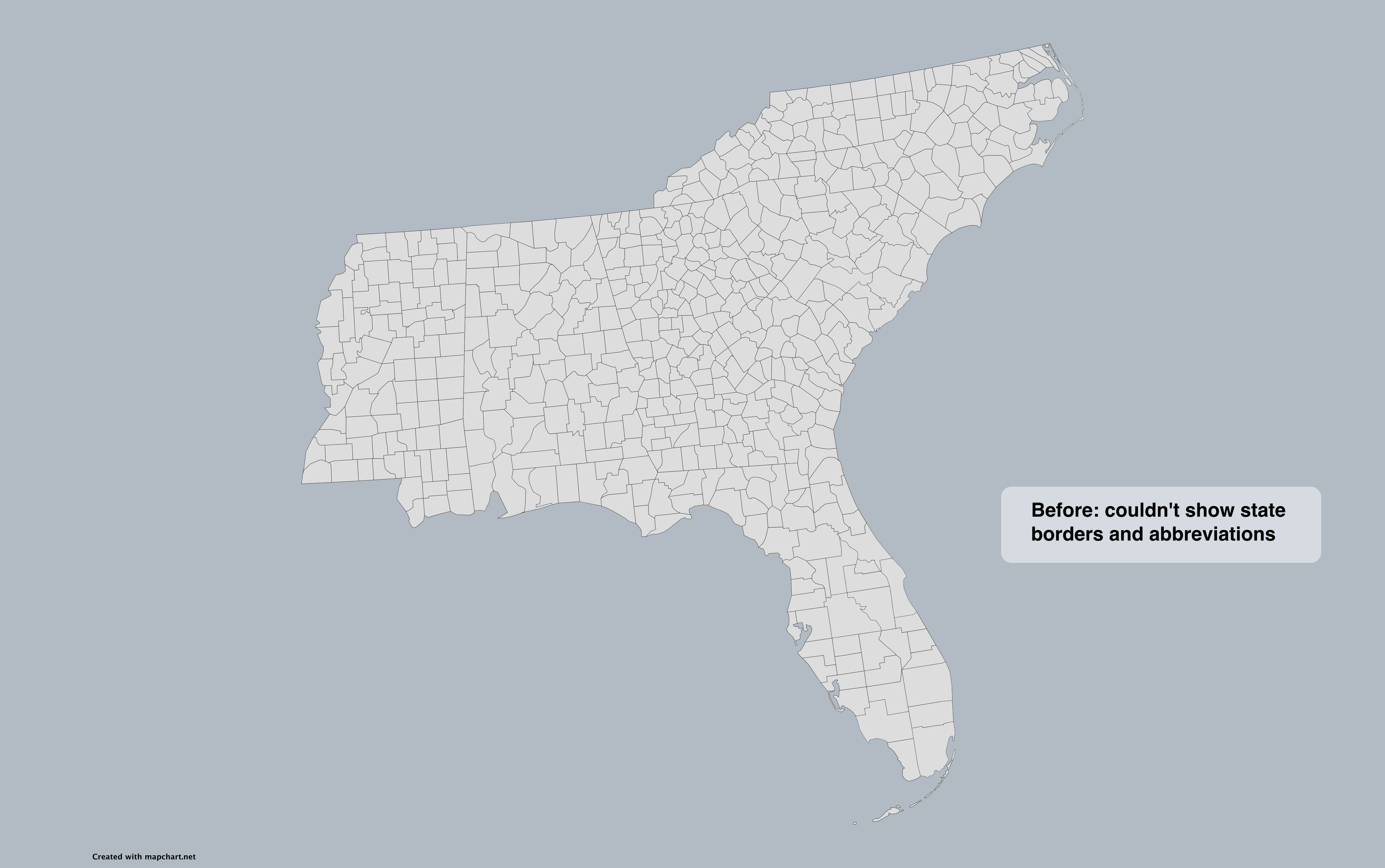
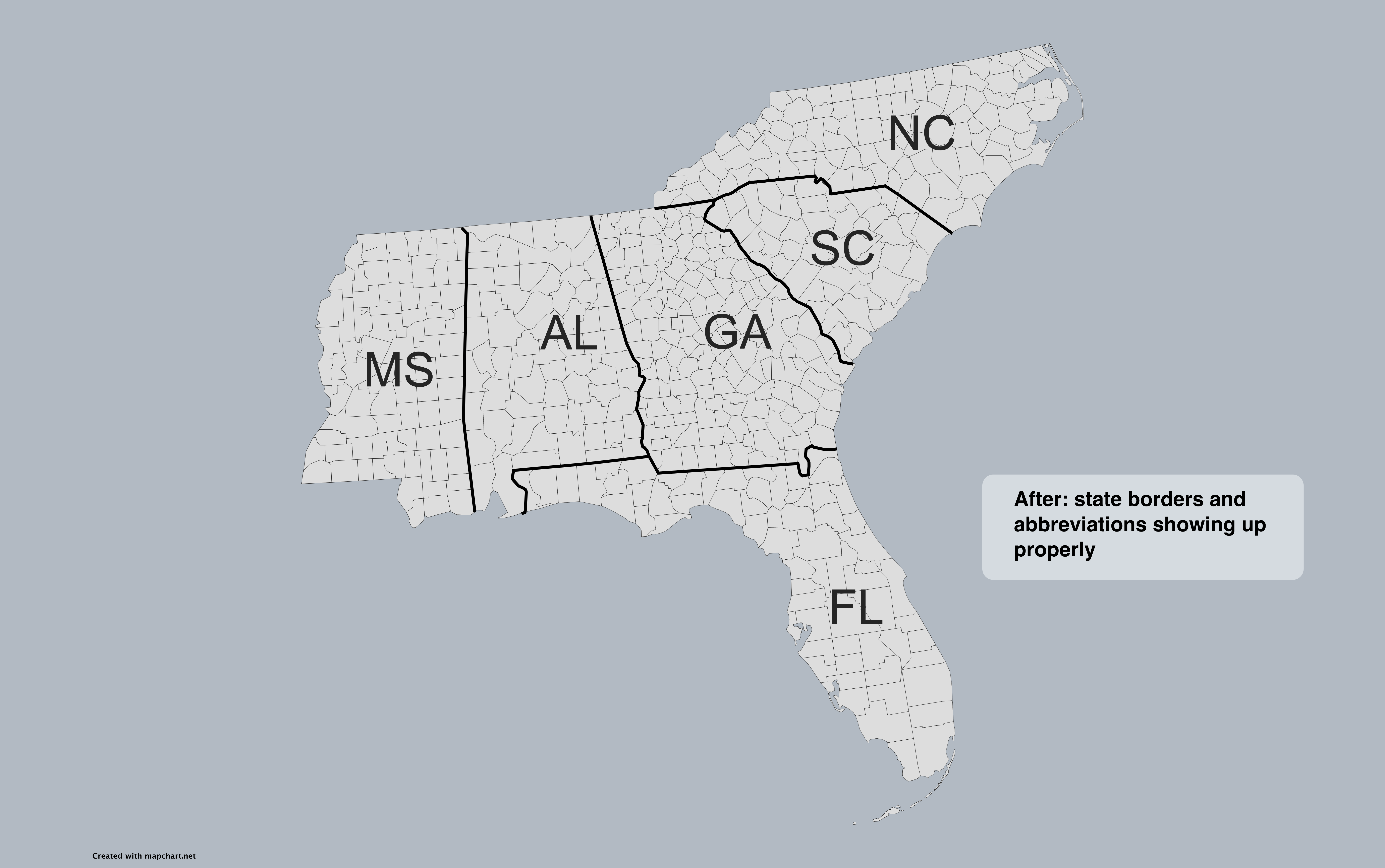
- Fixed an issue with the border width of subdivisions not behaving correctly.
- World 1880 map: fixed border between Romania/Russian Empire, and Serbia/Ottoman Empire.
Version 3.6.2 - 10 January 2023
- Europe detailed map: added City of London province to the United Kingdom.
- World 1880 map: fixed border between Persia and the Russian Empire.
- World 1880 map: fixed border between Italy and France.
- World 1815, World 1880, World 1914, and World 1938 maps: added Monaco, Liechtenstein, Andorra, San Marino, and Vatican City where applicable.
Version 3.6.1 - 5 January 2023
- Hearts of Iron IV - Provinces map: fixed an issue with Onega_01 province.
Version 3.6.0 - 3 January 2023
- Happy New Year 🎆! Best wishes to you and your loved ones! 🎉
- NEW! When selecting a custom color, you can now input it in HSL and RGB color formats, along with the existing hex format (e.g. #00ff00 can also be inputted as 0, 255, 0 in RGB and 120, 100%, 50% in HSL).
- The custom color picker has been improved, and now you can preview the value of the color when dragging inside the color gradient square.
- You can switch the current color format with the ↕️ button next to the color input. Your choice will be remembered for future visits.
-
Check the new custom color picker ⬇️
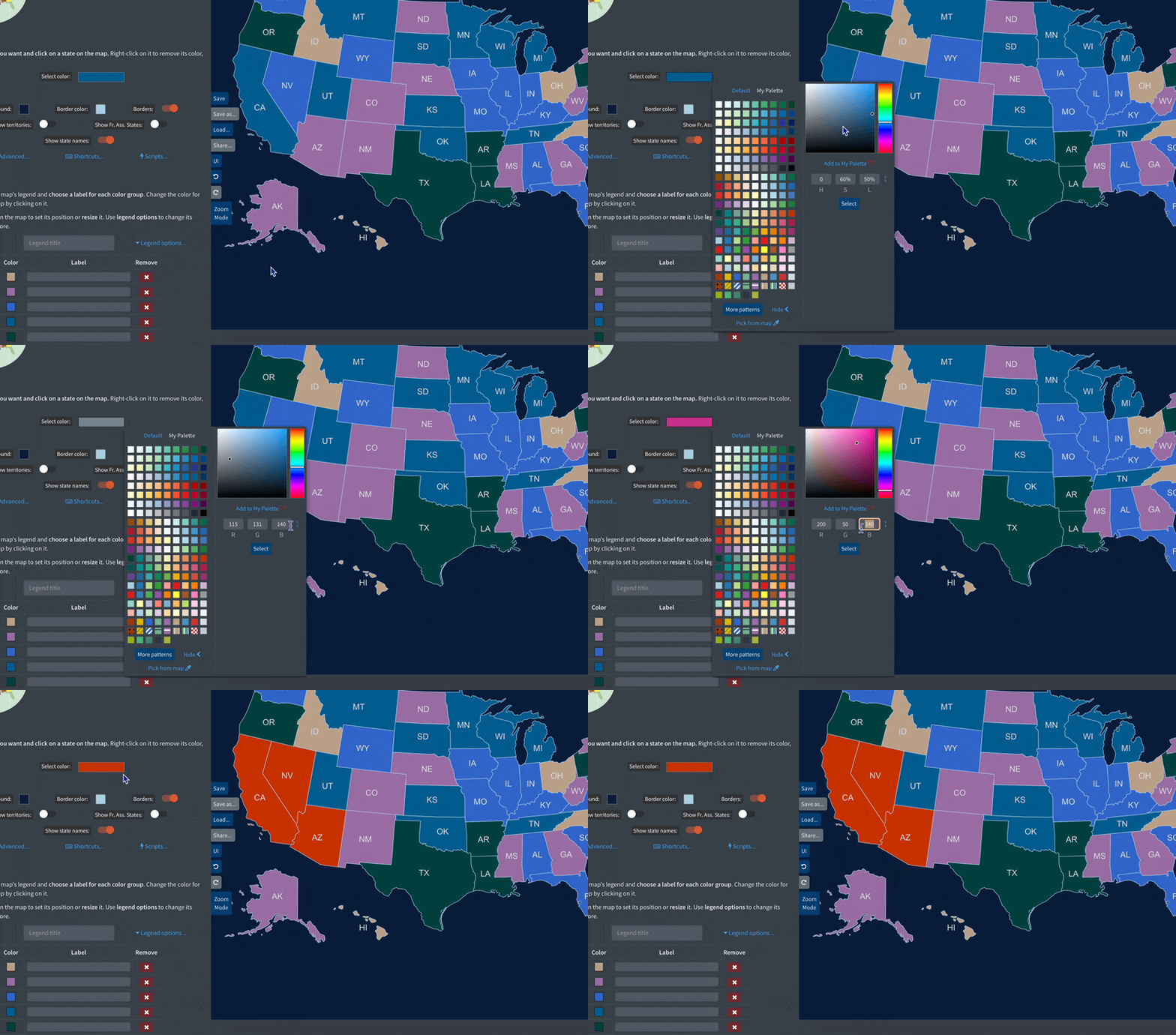
- Fixes and improvements to maps:
- World subdivisions: merged Komi-Permyak_RU and Perm_RU to Perm_Krai_RU.
- Europe detailed: removed Komi-Permyak_RU.
- Asia detailed: renamed Perm_RU to Perm_Krai_RU.
- World with Microstates: renamed East Timor to Timor Leste 🇹🇱 for consistency purposes. It also now displays its real world shape instead of a circle.
- Netherlands: merged the municipalities of Brielle, Hellevoetsluis, and Westvoorne to the newly formed Voorne aan Zee municipality.
- Croatia 🇭🇷 is now part of the Eurozone and the Schengen area! Updated the Region Selection feature of the world maps to reflect the addition.
Version 3.5.5 - 29 December 2022
- You can now display county name labels in the UK historic counties map.
- Fixed an issue with the Find uncolored countries ⚡️ Script not working on the Caribbean map.
Version 3.5.4 - 28 December 2022
- [Plus] Fixed an issue where some map configurations would not load for some users.
Version 3.5.3 - 22 December 2022
- When using coloring shortcuts, like holding Ctrl and moving over the map, or Option/Alt-Shift-clicking on a subdivision, you will now see a different cursor, to help making more accurate selections.
- Fixed an issue where Option/Alt-Shift-clicking on a subdivision for the second time, would not color the currently clicked subdivision.
- Hearts of Iron IV provinces map:
- Fixed the name of Qinghai state's provinces.
- Renamed Northeastern Canada provinces to Northern Manitoba.
- Redesignated the previously named Northeastern Canada 01 province to Nord du Quebec.
- Fixed León and Diyarbakır states' province names.
- Redesignated the previously named Onega 01 province to Murmansk. Renamed Onega 36 to Onega 01.
Version 3.5.2 - 16 December 2022
- Fixed an issue with the height of the USA Counties map when in Preview mode.
Version 3.5.1 - 13 December 2022
- Fixed an issue with changing the UI layout to simple or simple (reversed) on the Hearts of Iron IV provinces map.
- Fixed an issue with the label of Northern Ireland in the simple World map.
Version 3.5.0 - 13 December 2022
-
🖌️ New free map themes! You can now find 5 new map themes to use as a starting point for your maps:
- ⬜️ Muted: based on grey hues.
- 🦈 Marine: dark blue-grey background, grey countries.
- 👑 Royal: regal purple and gold.
- 🛸 Modern: light grey backround, white countries.
- 📜 Ancient: feels like a 15th century exploration chart.
- Big thanks to @Apollo3994, @micio_miciò☭, @RedCelcius01, and @idk_WhatMyNameIs from the unofficial Discord server, for designing the themes and contributing them to the website!
Version 3.4.2 - 12 December 2022
- MapChart birthday deal: Get 40% off MapChart Plus!
- Celebrate 8 years of map-making excellence!
- The discount is valid for new subscriptions and all your future renewals.
Version 3.4.1 - 7 December 2022
- Hearts of Iron IV Provinces map: added accentuated letters to province names and fixed names for Sachsen, Leon, Harju, Diyarbakir, Volgodonsk, Afyon and Northern Malay.
Version 3.4.0 - 6 December 2022
- New map! The Hearts of Iron IV - Provinces map is now available! NEW!
- It has around 10,000 provinces to work with, making it by far the most detailed map you can find on the website!
- You can also use the available shortcuts to color it quickly. For example, try holding Option/Alt+Shift and clicking on any province!
- Try also using the random color script (Step 1 > Scripts...) for a colorful spectacle!
- Beware that due to its size, this map can be heavy to load and use in some circumstances.
- The map is updated to reflect the latest HoI IV patch (v.1.12).
- Special thanks to @Kyx from the unofficial Discord server for the map template.
- A states overlay that you can toggle on/off will be added soon.
- Europe NUTS 3 map: In Italy's regions, removed ITG27, corrected ITI31 and ITH59, and split ITI34 into ITI34 and ITI35.
- When using keyboard shortcuts to color a map, you will now see again a different cursor (for example, a bucket icon when coloring en masse, or a target icon when coloring by state).
Version 3.3.9 - 4 December 2022
- World-1880 map: Added British Cyprus to the map.
Version 3.3.8 - 25 November 2022
- BLACK FRIDAY deal! Get 40% off MapChart Plus.
- The discount is valid for new subscriptions and all your future renewals!
Version 3.3.7 - 24 November 2022
- Fixed some layout issues with the More Maps menu dropdown.
Version 3.3.6 - 22 November 2022
- Fixed an issue with retrieving a Plus user's email on the Welcome page.
- World - Wargames map: Added some margin at the left side of the map to make Hawaii's hexagon accessible.
- World 1880 map: Fixed an issue with the Ottoman Empire borders.
Version 3.3.5 - 15 November 2022
- Fixed an issue with the border width of counties/districts for isolated states in the US counties and US Congressional districts maps.
Version 3.3.4 - 13 November 2022
- Added the ability to show/hide the tooltip (with the country's name) when hovering over the map. Find it in Step 1 > Advanced...
- Fixed the tooltip's positioning.
Version 3.3.3 - 1 November 2022
- World 1914 map: fixed a typo in Anglo-Egyptian Sudan's name.
- Minor UI improvements.
Version 3.3.2 - 30 October 2022
- Fixed an issue with the width of borders in Ukraine and Romania maps.
Version 3.3.1 - 29 October 2022
- Fixed an issue with the pattern color pickers not working.
Version 3.3.0 - 28 October 2022
⚡️ Big performance improvements! NEW!
-
You should see a big improvement to the zoom mode's smoothness. Zooming in/out and moving the map around should feel a lot more snappier and responsive, even on the largest maps.
Example before/after of zooming in/out a fully colored World Wargames map ⬇️
- There is now no limit to zooming in.
- Added a couple of zoom settings (inverting X/Y axis).
- Added a tutorial with all the available zoom options and shortcuts.
- Added more keyboard shortcuts for zoom mode: + - to zoom in/out, the keyboard arrows to move the map, R to reset, and Esc to stop zooming.
- Zoom Mode is now available on all maps.
- When hitting Preview Map, the map is not blurry now and loads a bit faster. This works on Chrome-like browsers and Firefox.
Version 3.2.4 - 21 October 2022
- Fixed an issue with thick borders randomly appearing when isolating countries on the World Subdivisions map.
Version 3.2.3 - 20 October 2022
- Minor performance improvements to loading of map pages.
Version 3.2.2 - 18 October 2022
- Added a few transparent background options in the Background color picker.
- Minor accessibility and performance improvements.
Version 3.2.1 - 17 October 2022
- Minor performance improvements.
Version 3.2.0 - 14 October 2022
-
As a Plus user, you can now generate a unique, shareable link 🌎 for your saved map.
NEW!
How to share a link to your map ⬇️
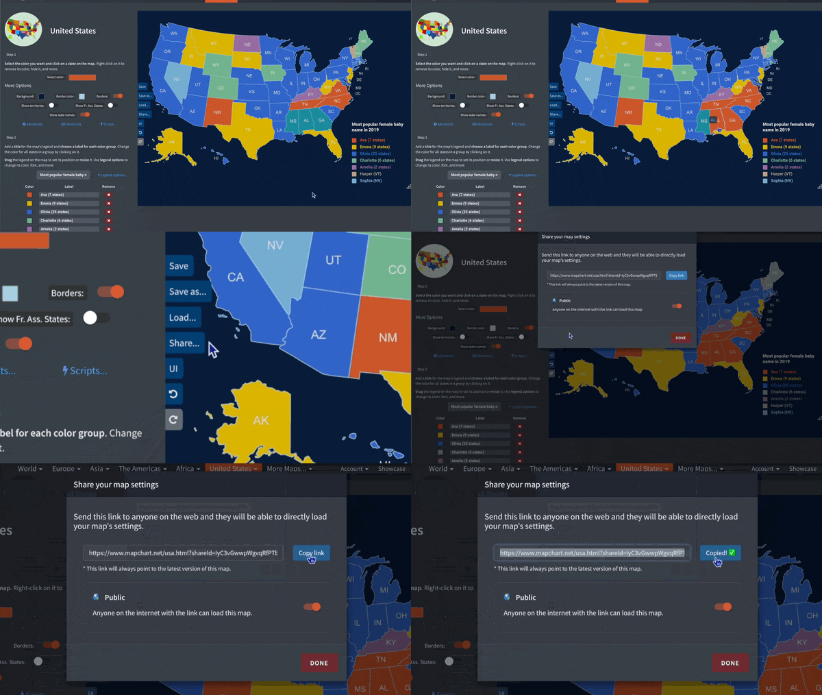
-
Anyone with the link (Plus user or not) can then use it to instantly load your map's settings and continue editing it or just check it out.
Using a shared link to load a map ⬇️
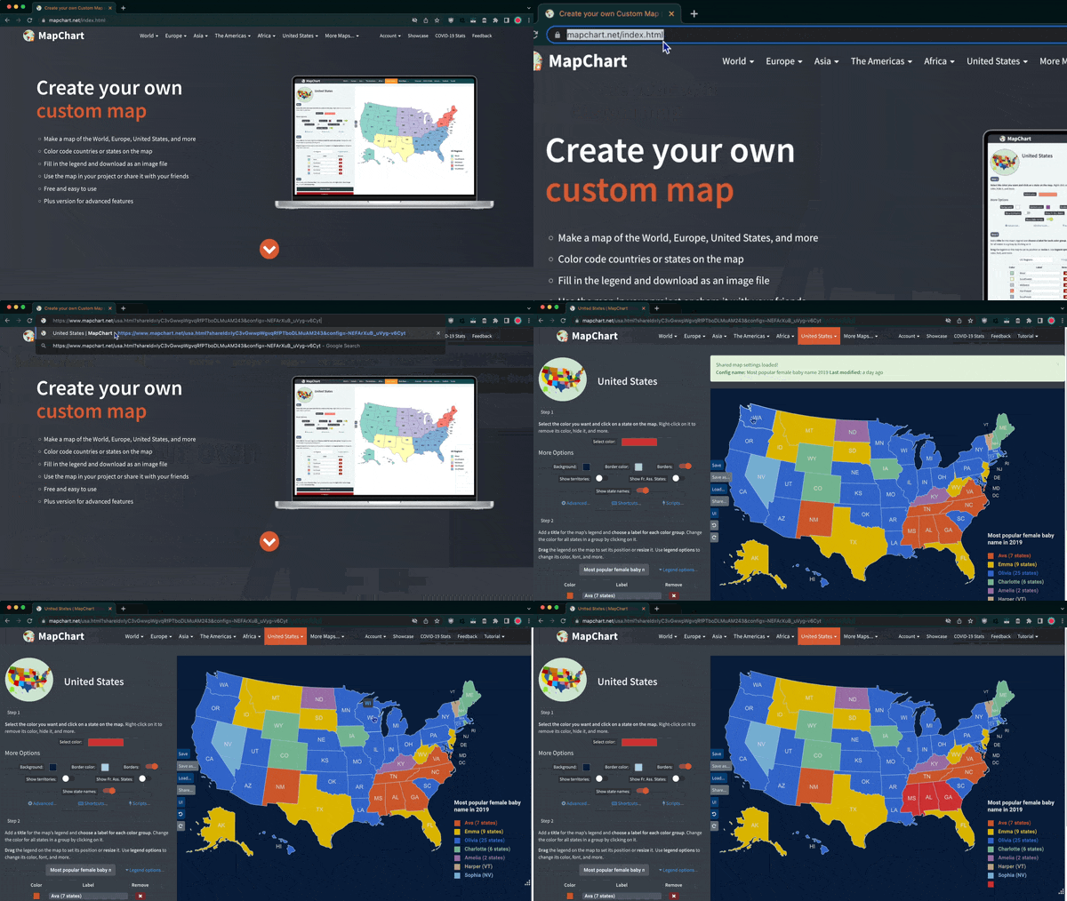
-
Creating a link to share:
This only works for maps that you have already saved to My Maps:
- While editing your map, hit the Share button at the left edge of the map.
- A link will be generated and this map configuration will be made publicly available. 🌎
- Copy the link and send it to anyone you want.
-
Using a link to load a map:
Anyone with the link can use it to load the map configuration you shared. When they visit it, the map settings will be instantly loaded on the map.
- See it in action: try opening any of the below shared map links (all shared by me!):
- Fixed an issue where changing the color of all countries of a color group would sometimes fail.
- World Subdivisions and Europe-Detailed maps: renamed West Bosnia subdivision to Canton 10 in Bosnia and Herzegovina 🇧🇦.
Version 3.1.2 - 13 October 2022
- Hearts of Iron IV map: added Saint Pierre and Miquelon and Socotra. Fixed issues with the outline of Stalinabad and Nigeria.
- World Subdivisions and Americas-Detailed maps: renamed Vargas subdivision to La Guaira in Venezuela 🇻🇪.
- World Subdivisions map: swapped the names of Napo and Tungurahua in Ecuador 🇪🇨.
Version 3.1.1 - 9 October 2022
- [Plus] Adapted the legend font picker dialog to the dark theme.
- Removed Isle of Man from the Europe map for consistency purposes.
- Fixed an issue with Stalinabad province on the updated Hearts of Iron IV map.
Version 3.1.0 - 6 October 2022
- ⚡️ Performance improvement: editing the map with basic actions like coloring or showing/hiding elements should now be much faster. This improvement should be most felt when working with maps with many countries/subdivisions. Undoing/redoing should also feel much snappier.
-
Example before/after of editing a fully colored US Counties map ⬇️
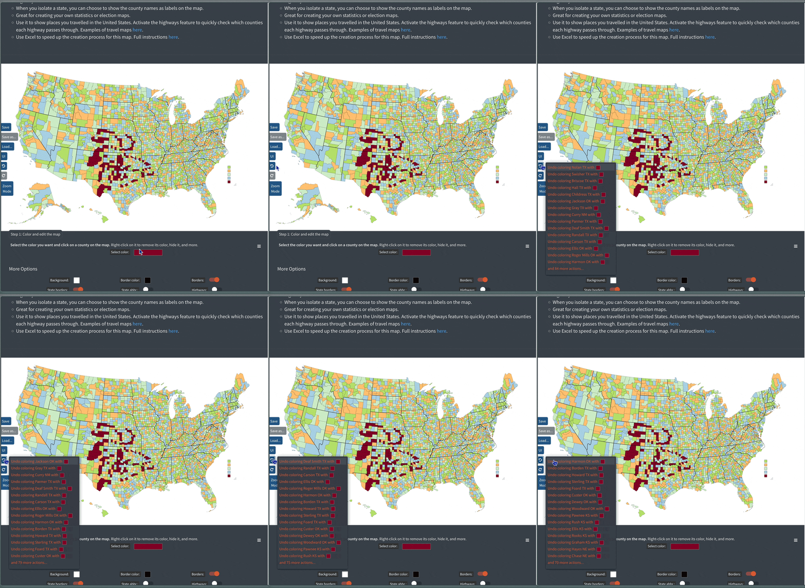
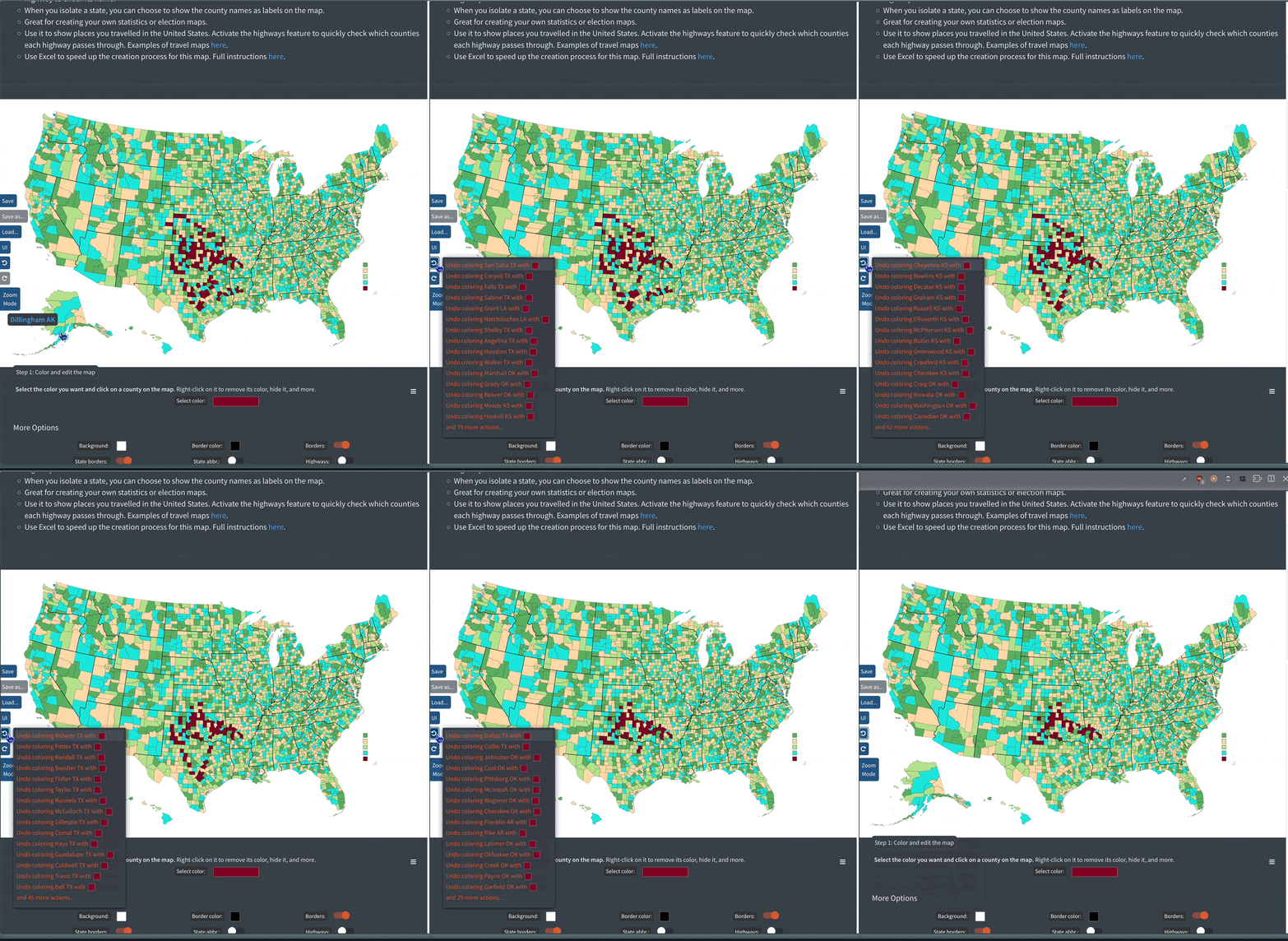
- [Plus] Fixed an issue where, when loading a map from the My Maps page, the Save As button remained disabled and greyed out.
- Fixed an issue with the Virginian peninsula missing on the updated Hearts of Iron IV map.
Version 3.0.5 - 5 October 2022
- Updated the Hearts of Iron IV map to the latest patch (1.12 "By Blood Alone").
- It now has around 99 new states, compared to the previous map.
-
Check which states have changed ⬇️
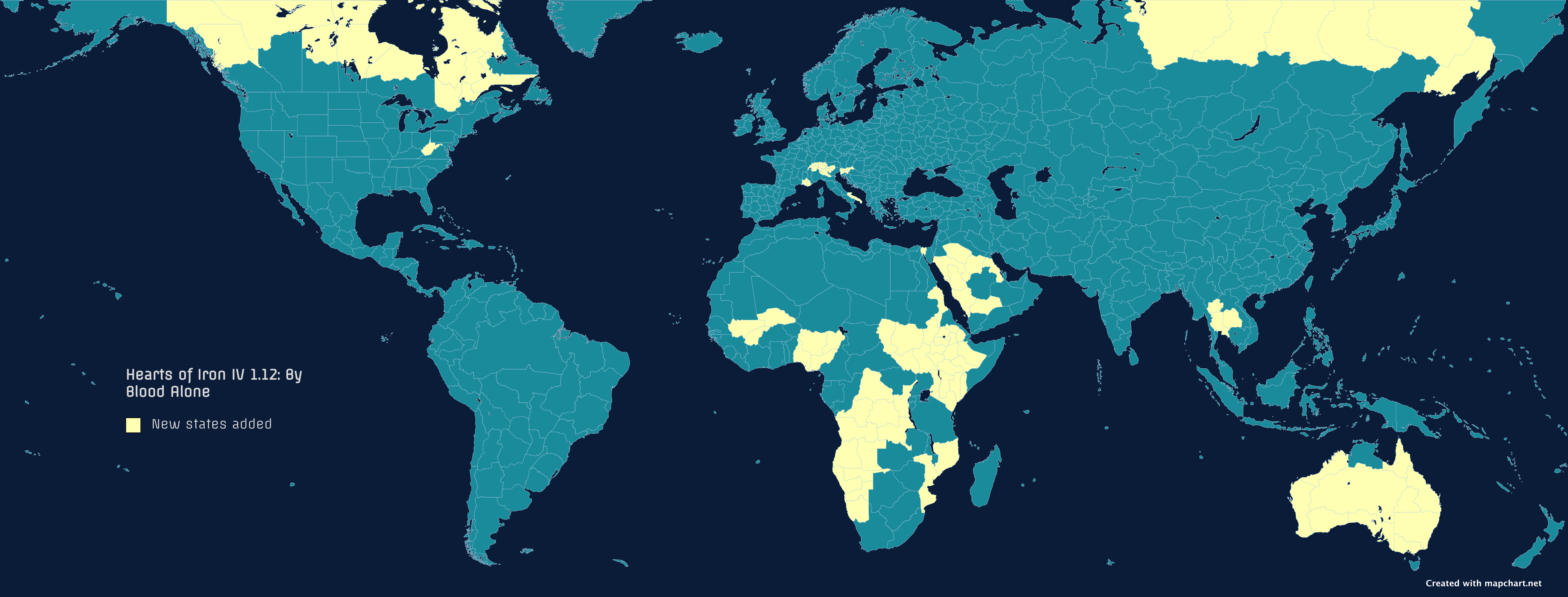
- Fixed an issue with Türkiye map's province names being on by default.
Version 3.0.4 - 5 October 2022
- Renamed St. Helena to Saint Helena on all maps.
- Fixed issues with some of the Hearts of Iron IV and EU IV province names.
- Fixed multiple subdivision names with accented characters (like Goiás, Curaçao, Diyarbakır, etc.)
Version 3.0.3 - 3 October 2022
- You can now customize what holding the Control button and moving over the map does. You can set it to:
- Color countries/states (the default).
- Hide countries/states.
- Do nothing.
-
See it in action ⬇️
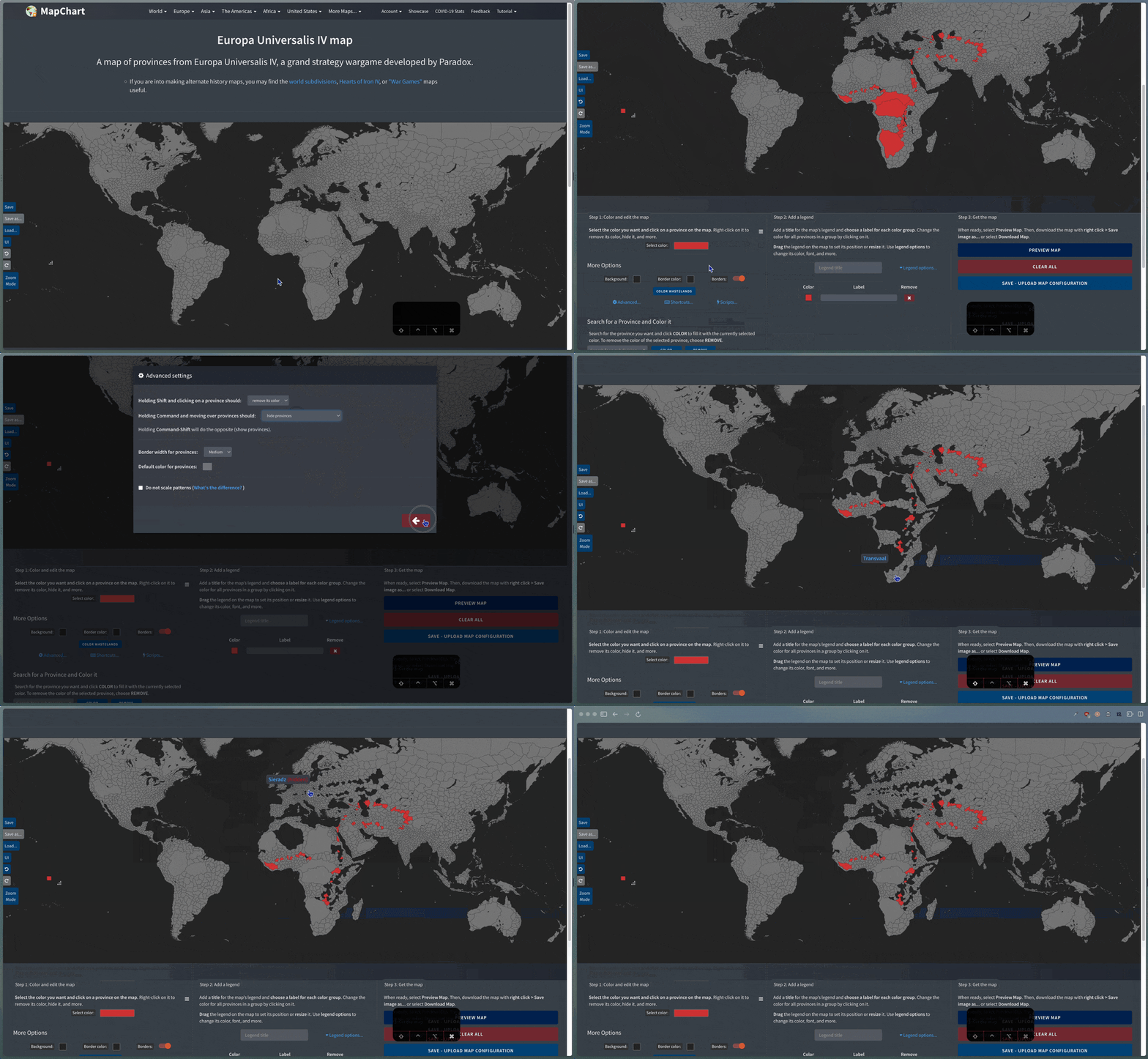
- Use these shortcuts to color or customize your maps even more quickly.
- Find this in the Advanced... settings dialog.
- The setting you choose is also saved to your browser's preferences, so you don't have to change it every time. The same also happens now for the Shift + click shortcut.
Version 3.0.2 - 30 September 2022
- Makeover of the Canada 🇨🇦 census divisions map! The map is now on a more suitable map projection and doesn't look squishy any more. Check out the updated Canada census divisions map!
- Fixes and improvements to maps:
- World Subdivisions and Asia Detailed maps: renamed Nepal 🇳🇵 provinces Province No.5 and Province No.2 to Lumbini Pradesh and Madhesh Pradesh.
- Cold War World map: fixed an issue with Solomon Islands not displayed on the map for years 1978 to 2016.
- Cold War World map: removed a redundant version of Yugoslavia for year 1992.
- Europe: the "Created with mapchart.net" tag is now displayed at the bottom left corner of the map.
Version 3.0.1 - 29 September 2022
- [Plus] Fixed an issue with loading a saved map straight from the My Maps page.
- Updated all references of Turkey across the website to Türkiye 🇹🇷.
- Updates to maps:
- World Subdivisions and Europe Detailed maps: updated Iceland's 🇮🇸 and Latvia's 🇱🇻 subdivisions. The maps now display Iceland's 8 regions and Latvia's 43 state cities and municipalities. You may need to update your saved maps.
- Fixes and improvements to maps:
- Hearts of Iron IV: fixed around 40 typos in province names.
- World with microstates: Montenegro 🇲🇪 is not shown as a circle any more, but with its real border outline.
Version 3.0.0 - 25 September 2022
- Announcing MapChart Plus! It's a brand new, premium version of the website and the mobile apps that gets you:
- 👤 Your own MapChart Plus account.
- 🗺 My Maps: save all maps you make to your account. No need to use text files any more!
- 🎨 My Palette: save your favourite colors and patterns to your account and find them quickly.
- 🚫 No ads.
- 🌙 A dark theme for the whole website.
- 🖌 5 extra map themes, to better customize your maps.
- 📲 The Premium Max version (costing 9.99$) of the mobile app (iOS or Android).
- You can join MapChart Plus via the Plus page.
- Relevant blog post.
- [Beta] The beta program is now over. Users that participated in it 1 year of MapChart Plus for free, as a reward for their invaluable feedback. Thanks again!
- Various UI improvements.
Version 2.17.1 - 6 September 2022
- Fixed an issue with previewing the Romania map.
Version 2.17.0 - 5 September 2022
- New map! A complete map of Romania's 🇷🇴 subdivisions (counties, communes, cities, and municipalities) is now available! You can also use the sliders in More Options to make counties colorable or transparent.
- Fixes and improvements to maps:
- Westeros: added again the option to change the color of city labels in Advanced.
- World Subdivisions and Asia Detailed: renamed Dəvəçi_AZ to Şabran_AZ.
- Europa Universalis IV: split Slesvig province to Slesvig and Fyn.
- Europa Universalis IV: fixed name of Cabo Verde.
- Europe: fixed borders between Wales and England when the "Split the UK" option is activated.
- Minor UI improvements.
- [Beta] Adapted Historical MapChart pages to the dark theme.
Version 2.16.5 - 28 August 2022
- In the color pickers, when you input your custom hex color, you will now be able to check a preview of it, before selecting. Pressing Enter to select your custom color will now work too.
- The "too many legend entries" warning will now automatically go away as you remove legend entries from the map.
- Various UI improvements.
- [Beta] You can now use your account on the Historical MapChart website as well.
- [Beta] Fixed handling errors when changing e-mail.
- [Beta] Added GIFs explaining the My Maps save/load process.
Version 2.16.4 - 16 August 2022
- Map fixes:
- World subdivisions: Added missing New Ireland province to Papua New Guinea.
- USA Congressional Districts: positioning of some state abbreviation labels.
- USA Counties: minor border fix in MA.
- Europa Universalis IV: fixed name of Vlaanderen province.
- Renamed references of Kiev to Kyiv in all maps.
Version 2.16.3 - 12 August 2022
- Small UI changes for map pages.
- [Beta] Added user and subscription information to Account page.
Version 2.16.2 - 7 August 2022
- Improvements and fixes for the Europa Universalis IV provinces map:
- You can now color all wastelands (impassables) with a single click, to speed-up map-making. Use the Color Wastelands button in the More Options section.
- Default color of some provinces.
- Name of the Noquet province.
Version 2.16.1 - 2 August 2022
- Fixes for the Europa Universalis IV provinces map:
- Added some bottom padding to the map.
- Fixed names of Cayman Islands, Irkutsk, Manokwari, Romsdal, Inner Hebrides, and Tokachi.
- Split the following provinces to be able to color them separately: The Alps, High Atlas, Egyptian Desert, and Zagros.
- Split Combahee to Combahee and Saluda.
- Split Noquet to Noquet and La Pointe.
Version 2.16.0 - 1 August 2022
- New map! The Europa Universalis IV provinces map is now available!
Version 2.15.2 - 28 July 2022
- USA Congressional Districts: Swapped WV01 with WV02 districts.
- Fixed a bug with uploading map configs to the World map with microstates page.
Version 2.15.1 - 26 July 2022
- You can now use the MapChart Configuration Export tool (for Windows and macOS) to export config files for the UK - Elections map as well.
- Fixes to maps:
- Hearts of Iron IV map: name of Yarkand subdivision.
- World Subdivisions/Asia-Detailed: split Papua_ID into three new subdivisions (Central Papua, Highland Papua, and South Papua), valid after 30th June 2022.
- World Subdivisions/Asia-Detailed: name of Zabaykalsky_Krai_RU subdivision.
Version 2.15.0 - 12 July 2022
- [Beta] Import configurations: You can now import all the map configurations you have in text files (.txt) to your account. Find it via the My Maps page and the Import from text files section.
- [Beta] Reordered the columns of the available map configurations tables.
- [Beta] The map configurations table in My Maps now shows the full name of the page that the map belongs to.
- World Subdivisions: Fixed Edineț_MD.
- US Congressional Districts: Fixed borders of Hawaii districts.
Version 2.14.14 - 2 July 2022
- Added changes to the Louisiana map for the US Congressional Districts map.
Version 2.14.13 - 30 June 2022
- Fixed issue where, when typing numbers (1 to 9) in the legend title or labels, the selected color would change.
Version 2.14.12 - 29 June 2022
- Fixed issue with the Background color picker not being able to be set to a color with transparency.
Version 2.14.11 - 28 June 2022
- Fixed issue with the Add Pattern dialog showing the wrong colors sometimes.
- [Beta] Fixed issue with the Add Pattern dialog not working via the 'My Palette' page.
Version 2.14.10 - 23 June 2022
- The US Congressional Districts map has been updated with all the redistricting changes for the upcoming 2022 midterm elections (118th Congress), except for the state of Louisiana, which hasn't approved a map yet. You can find the previous (117th Congress) map, via the Select Congress option on the page. The Excel tools have also been updated.
- Fixed an issue where when using the Clear All button, the map theme was also set to the Default one. Now, it should preserve your currently preferred map theme and only clear your edits on the map.
Version 2.14.9 - 21 June 2022
- Added links to the unofficial subreddit and Discord server for MapChart in the page's footer.
- Fixes and improvements:
- For maps with state borders and abbreviations (US Counties, US Congressional Districts, EU NUTS maps, US electoral cartogram):
- State borders now have the same color as the subdivision borders.
- State abbreviations now have the same color as the subdivision labels (if any).
- Fixed some inconsistencies when isolating a state in the US counties map.
- Better handling of custom colors. If you manually enter an invalid color, you will see an appropriate error message. Also, if you are selecting a custom color, the legend box in Step 2 will be updated as well.
- The More Maps menu on the navigation bar is now wider and with a 3 column layout.
- Fixed issue with the color picker getting cut off when opening it from the Add Pattern dialog.
- World Subdivisions/Europe Detailed: Fixed labels and errors in Moldavia and Romania:
- Romania labels: Timiș, Caraș-Severin, Mehedinți, Sălaj, Maramureș, Bistrița-Năsăud, Mureș, Brașov, Argeș, Dâmbovița, Buzău, Brăila, Ialomița, Constanța, Galați, Bacău, Neamț, Iași and Botoșani.
- Moldova labels: Ocnița, Dondușeni, Edineț, Rîșcani, Bălți, Fălești, Florești, Telenești, Călărași, Șoldănești, Strășeni, Chișinău, Hîncești, Cimișlia, Căușeni and Ștefan Vodă.
- Merged Cainari district into Căușeni.
- Renamed Bender to Slobozia.
- Changed some of Transistria's districts to group as OT (other, autonomous, unrecognized) instead of MD (Moldova).
- For maps with state borders and abbreviations (US Counties, US Congressional Districts, EU NUTS maps, US electoral cartogram):
- [Beta] In the color picker, right-clicking on a color from the palette will now show options to Add or Remove it to/from My Palette.
- [Beta] When loading a config from My Maps, if there is an error, an error dialog will appear with diagnostics info.
- [Beta] When saving a config to My Maps, you can now hit Enter/Return in the dialog to save.
Version 2.14.8 - 12 June 2022
- Fixes and improvements:
- Entering an invalid color when selecting a custom color now shows an error message.
- World - Advanced: fixed behavior of zoom mode when changing map projection.
- US hex cartogram: electoral votes count is now updated properly when a configuration is restored or using the random color Script.
- Tamriel: removed a switch that did nothing from More Options section.
- US Counties: better UI behavior when isolating a state.
- Italy: fixed default color of Agrigento district.
- UK: fixed label of Kincardineshire.
- UK (historic): fixed Norfolk not being hidden when hiding all of Great Britain.
- [Beta] Fixed color of rows in Load dialog and My Maps table.
- [Beta] Fixed export functionality of My Maps.
- [Beta] Fixed color of random color Script dropdown.
Version 2.14.7 - 10 June 2022
- The beta program is now under way! The 50 selected users are already reporting bugs for the new, experimental features. These will also be tracked here.
- Fixed an issue with not being able to remove a row from the legend after changing its color.
- Fixed names and spellings on the following maps:
- World Subdivisions and Europe - Detailed: names of Arkhangelsk, Agion Oros, Ivano-Frankivsk, Khmelnytskyi, Lviv, Dnipropetrovsk, Donetsk, Luhansk, Sjælland, Örebro.
- Belgium: names of municipalities of Saint Nicolas and Sint Niklaas.
- The Caribbean: label of Saint Barthelemy.
- Netherlands: names of Noardeast-Fryslân and Sudwest-Fryslân.
- Tamriel: names of Stros M' Kai Archipelago and Helstrom Region, labels of Stros M' Kai and Cheydinhal.
- Fixed an issue on the map of Italy with the district of Agrigento.
- [Beta] Fixed styling issues on loading configuration tables and map themes.
- [Beta] Fixed export button functionality in My Maps page.
Version 2.14.6 - 3 June 2022
- A new setting for the Make a Map of a Single Country/State and Isolate Multiple Countries/States options: you can now set if the colors and data of other subdivisions should be cleared. Example:
- On the US counties map, you color some counties in Texas (TX) 🟥 , some in California (CA) 🟦 , and some in Alabama (AL) 🟨 .
- You isolate the state of Texas (TX) 🟥 .
- If Clear colors of other counties is checked, the 🟦 and 🟨 colors (from the now hidden CA and AL counties) will be removed (cleared) from the map. This is the default behavior.
- If Clear colors of other counties is unchecked, the 🟦 and 🟨 colors (from the now hidden CA and AL counties) will not be removed from the map. If you select Show All you will be able to see them again.
- Fixed: using the random color Script now adds the generated colors in the palette.
Version 2.14.5 - 30 May 2022
- Fixed issue with some pages not loading in Safari on iPads.
- Fixed Chaharmahal and Bakhtiari province in Asia Detailed and World subdivisions maps. It previously was wrongly labelled as Esfahan.
- Renamed the "Preferences" button back to "UI".
Version 2.14.0 - 28 May 2022
- New beta program to test major upcoming features. Find out more in the beta signup page.
- Map themes! You can now select a pre-defined map theme for all your maps:
- ⚪️ Default: white background, grey countries
- ⚫️ Dark: dark background, dark grey countries
- 🔵 Aqua: light blue background, light grey countries
- New legend option: you can now split the legend into two columns. Useful for maps with many legend entries. Find it via the Legend Options option in Step 2.
- New feature: Map Scripts! You can now use
Scripts to quickly color or get data from a map. These include:
- Random color: Randomly colors the whole map.
- Random color by group: Randomly colors the whole map by group (country or state). Available only on relevant maps.
- Find uncolored: Scans the map for countries that are uncolored and outputs them as a list.
- Count: Outputs the total number of elements on the map.
- Count by group: Outputs the total number of elements on the map by group (country or state). Available only on relevant maps.
- List: Get a comma-separated list of all countries/states on the map.
- New shortcut: You can now use numpad shortcuts (keys 1 to 9) to select a already used color.
- Fixed an issue with the US Counties map and the state borders.
- Isolating a state in the US Counties map now zooms in to the state progressively.
- Added this Changelog page, to track all updates of the website.
- Fixed an issue with the Europe maps and the location of the islands next to Mallorca.
- Added a link to the licensing section in the footer.
- Multiple fixes to the UI of the website:
- When you use the Clear All option, a info message is shown, stating that you can use the Undo option.
- Redesign of the various on/off switches.
- The Edit button is now only shown when in Preview Map mode.
- Fixed issues with the layout of the More Options section.
- Fixed issues with the functionality of the More Options section.
- Added proper placeholders for the Isolate Multiple elements and Color Multiple elements sections.
- Fixed issues with the Simple UI layout.
- Renamed the UI button to Preferences, which also contains the map theme switcher.